You are here: Home > Network List > JP - Japan Meteorological Agency Seismic Network Stations List
> Station JNU Oita Nakatsue > Earthquake Result Viewer
JNU Oita Nakatsue - Earthquake Result Viewer
| Earthquake location: |
Tonga Islands Region |
| Earthquake latitude/longitude: |
-22.2/-174.3 |
| Earthquake time(UTC): |
2020/05/28 (149) 07:18:44 GMT |
| Earthquake Depth: |
10 km |
| Earthquake Magnitude: |
5.9 mww |
| Earthquake Catalog/Contributor: |
NEIC PDE/us |
|
| Network: |
JP Japan Meteorological Agency Seismic Network |
| Station: |
JNU Oita Nakatsue |
| Lat/Lon: |
33.12 N/130.88 E |
| Elevation: |
540 m |
|
| Distance: |
75.9 deg |
| Az: |
314.988 deg |
| Baz: |
128.658 deg |
| Ray Param: |
0.051341787 |
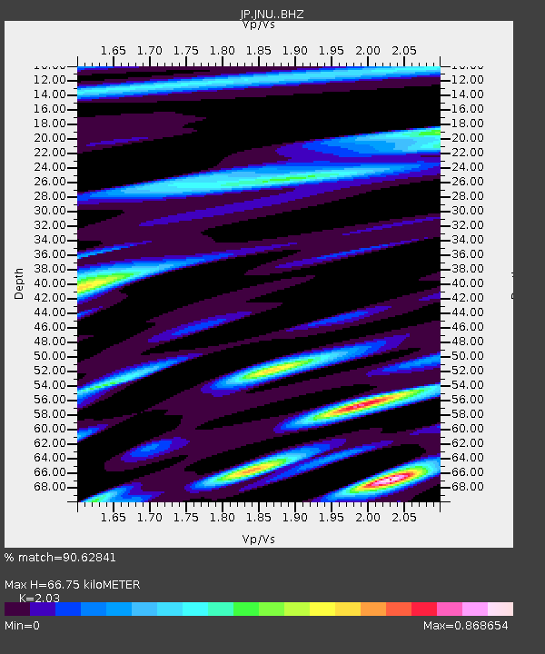
| Estimated Moho Depth: |
66.75 km |
| Estimated Crust Vp/Vs: |
2.03 |
| Assumed Crust Vp: |
6.468 km/s |
| Estimated Crust Vs: |
3.186 km/s |
| Estimated Crust Poisson's Ratio: |
0.34 |
|
| Radial Match: |
90.62841 % |
| Radial Bump: |
400 |
| Transverse Match: |
87.27815 % |
| Transverse Bump: |
400 |
| SOD ConfigId: |
21166931 |
| Insert Time: |
2020-06-11 07:34:45.207 +0000 |
| GWidth: |
2.5 |
| Max Bumps: |
400 |
| Tol: |
0.001 |
|

Signal To Noise
| Channel | StoN | STA | LTA |
| JP:JNU: :BHZ:20200528T07:30:00.349986Z | 8.08747 | 6.866501E-7 | 8.490296E-8 |
| JP:JNU: :BHN:20200528T07:30:00.349986Z | 2.699814 | 1.952462E-7 | 7.231839E-8 |
| JP:JNU: :BHE:20200528T07:30:00.349986Z | 2.308012 | 2.0441864E-7 | 8.8569145E-8 |
| Arrivals |
| Ps | 11 SECOND |
| PpPs | 30 SECOND |
| PsPs/PpSs | 41 SECOND |


