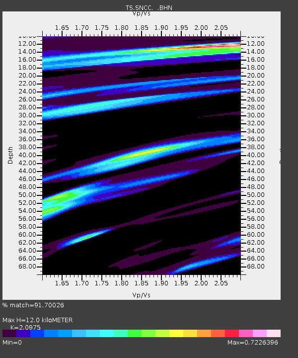
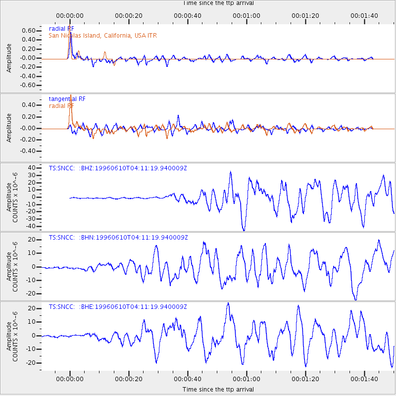
SNCC San Nicolas Island, California, USA - Earthquake Result Viewer

Earthquake location: Andreanof Islands, Aleutian Is.
Earthquake latitude/longitude: 51.6/-177.6
Earthquake time(UTC): 1996/06/10 (162) 04:03:35 GMT
Earthquake Depth: 33 km
Earthquake Magnitude: 6.6 MB, 7.6 MS, 7.9 UNKNOWN, 7.4 MS
Earthquake Catalog/Contributor: WHDF/NEIC
Network: TS TERRAscope (Southern California Seismic Network)
Station: SNCC San Nicolas Island, California, USA
Lat/Lon: 33.25 N/119.52 W
Elevation: 227 m
Distance: 45.4 deg
Az: 90.424 deg
Baz: 311.853 deg
Ray Param: 0.07126324
Estimated Moho Depth: 12.0 km
Estimated Crust Vp/Vs: 2.10
Assumed Crust Vp: 6.048 km/s
Estimated Crust Vs: 2.883 km/s
Estimated Crust Poisson's Ratio: 0.35
Radial Match: 91.70026 %
Radial Bump: 366
Transverse Match: 85.594955 %
Transverse Bump: 400
SOD ConfigId: 6273
Insert Time: 2010-02-26 14:51:34.448 +0000
GWidth: 2.5
Max Bumps: 400
Tol: 0.001

Signal To Noise

ChannelStoNSTALTA
TS:SNCC: :BHN:19960610T04:11:19.940009Z1.51597796.0633585E-73.9996354E-7
TS:SNCC: :BHE:19960610T04:11:19.940009Z1.38240736.544036E-74.7337974E-7
TS:SNCC: :BHZ:19960610T04:11:19.940009Z4.189692.2741713E-65.428018E-7
Arrivals
Ps2.3 SECOND
PpPs5.9 SECOND
PsPs/PpSs8.1 SECOND