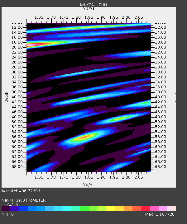
KZA KN.KZA - Earthquake Result Viewer
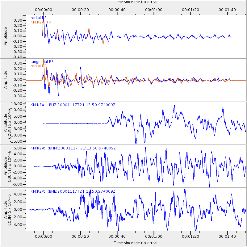
Earthquake location: New Britain Region, P.N.G.
Earthquake latitude/longitude: -5.5/151.8
Earthquake time(UTC): 2000/11/17 (322) 21:01:56 GMT
Earthquake Depth: 33 km
Earthquake Magnitude: 6.2 MB, 8.0 MS, 7.6 MW, 6.9 ME
Earthquake Catalog/Contributor: WHDF/NEIC
Network: KN Kyrgyz Seismic Telemetry Network
Station: KZA KN.KZA
Lat/Lon: 42.08 N/75.25 E
Elevation: 3520 m
Distance: 83.7 deg
Az: 313.252 deg
Baz: 103.12 deg
Ray Param: 0.045930956
Estimated Moho Depth: 19.0 km
Estimated Crust Vp/Vs: 1.60
Assumed Crust Vp: 6.306 km/s
Estimated Crust Vs: 3.941 km/s
Estimated Crust Poisson's Ratio: 0.18
Radial Match: 96.77696 %
Radial Bump: 400
Transverse Match: 95.02388 %
Transverse Bump: 400
SOD ConfigId: 3744
Insert Time: 2010-03-08 20:28:25.497 +0000
GWidth: 2.5
Max Bumps: 400
Tol: 0.001

Signal To Noise

ChannelStoNSTALTA
KN:KZA: :BHN:20001117T21:13:50.974009Z1.63291671.3281307E-78.133487E-8
KN:KZA: :BHE:20001117T21:13:50.974009Z1.75806452.3647398E-71.3450814E-7
KN:KZA: :BHZ:20001117T21:13:50.974009Z2.5044992.9383312E-71.17322124E-7
Arrivals
Ps1.9 SECOND
PpPs7.6 SECOND
PsPs/PpSs9.5 SECOND