You are here: Home > Network List > NN - Western Great Basin/Eastern Sierra Nevada Stations List
> Station PAH Pah Rah Range, Nevada w84gm > Earthquake Result Viewer
PAH Pah Rah Range, Nevada w84gm - Earthquake Result Viewer
| Earthquake location: |
Tonga Islands Region |
| Earthquake latitude/longitude: |
-22.2/-174.3 |
| Earthquake time(UTC): |
2020/05/28 (149) 07:18:44 GMT |
| Earthquake Depth: |
10 km |
| Earthquake Magnitude: |
5.9 mww |
| Earthquake Catalog/Contributor: |
NEIC PDE/us |
|
| Network: |
NN Western Great Basin/Eastern Sierra Nevada |
| Station: |
PAH Pah Rah Range, Nevada w84gm |
| Lat/Lon: |
39.71 N/119.39 W |
| Elevation: |
1520 m |
|
| Distance: |
80.1 deg |
| Az: |
39.837 deg |
| Baz: |
230.303 deg |
| Ray Param: |
0.04849848 |
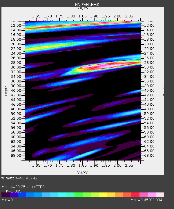
| Estimated Moho Depth: |
29.25 km |
| Estimated Crust Vp/Vs: |
1.88 |
| Assumed Crust Vp: |
6.279 km/s |
| Estimated Crust Vs: |
3.331 km/s |
| Estimated Crust Poisson's Ratio: |
0.30 |
|
| Radial Match: |
90.91742 % |
| Radial Bump: |
384 |
| Transverse Match: |
83.30435 % |
| Transverse Bump: |
400 |
| SOD ConfigId: |
21166931 |
| Insert Time: |
2020-06-11 07:36:24.118 +0000 |
| GWidth: |
2.5 |
| Max Bumps: |
400 |
| Tol: |
0.001 |
|

Signal To Noise
| Channel | StoN | STA | LTA |
| NN:PAH: :HHZ:20200528T07:30:23.534983Z | 14.541753 | 1.124169E-6 | 7.730629E-8 |
| NN:PAH: :HHN:20200528T07:30:23.534983Z | 3.74335 | 2.7914004E-7 | 7.4569584E-8 |
| NN:PAH: :HHE:20200528T07:30:23.534983Z | 3.7694166 | 3.3919648E-7 | 8.9986465E-8 |
| Arrivals |
| Ps | 4.2 SECOND |
| PpPs | 13 SECOND |
| PsPs/PpSs | 17 SECOND |


