You are here: Home > Network List > KN - Kyrgyz Seismic Telemetry Network Stations List
> Station KZA KN.KZA > Earthquake Result Viewer
KZA KN.KZA - Earthquake Result Viewer
| Earthquake location: |
Irian Jaya, Indonesia |
| Earthquake latitude/longitude: |
-3.1/136.1 |
| Earthquake time(UTC): |
2000/08/12 (225) 10:26:15 GMT |
| Earthquake Depth: |
33 km |
| Earthquake Magnitude: |
5.6 MB, 5.7 MS, 6.0 MW, 5.9 MW |
| Earthquake Catalog/Contributor: |
WHDF/NEIC |
|
| Network: |
KN Kyrgyz Seismic Telemetry Network |
| Station: |
KZA KN.KZA |
| Lat/Lon: |
42.08 N/75.25 E |
| Elevation: |
3520 m |
|
| Distance: |
70.9 deg |
| Az: |
316.532 deg |
| Baz: |
112.667 deg |
| Ray Param: |
0.05459541 |
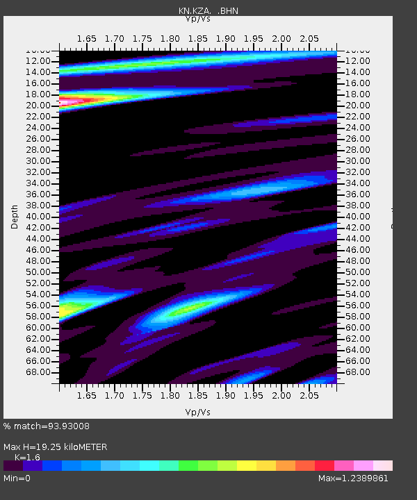
| Estimated Moho Depth: |
19.25 km |
| Estimated Crust Vp/Vs: |
1.60 |
| Assumed Crust Vp: |
6.306 km/s |
| Estimated Crust Vs: |
3.941 km/s |
| Estimated Crust Poisson's Ratio: |
0.18 |
|
| Radial Match: |
93.93008 % |
| Radial Bump: |
392 |
| Transverse Match: |
92.53845 % |
| Transverse Bump: |
400 |
| SOD ConfigId: |
3744 |
| Insert Time: |
2010-03-08 20:28:36.734 +0000 |
| GWidth: |
2.5 |
| Max Bumps: |
400 |
| Tol: |
0.001 |
|
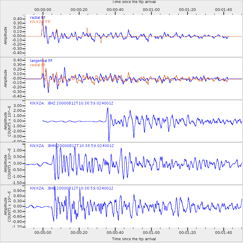
Signal To Noise
| Channel | StoN | STA | LTA |
| KN:KZA: :BHN:20000812T10:36:59.024001Z | 1.5964726 | 8.1046615E-8 | 5.0766054E-8 |
| KN:KZA: :BHE:20000812T10:36:59.024001Z | 0.59777594 | 2.4277256E-8 | 4.0612633E-8 |
| KN:KZA: :BHZ:20000812T10:36:59.024001Z | 1.0191901 | 7.357565E-8 | 7.219032E-8 |
| Arrivals |
| Ps | 1.9 SECOND |
| PpPs | 7.6 SECOND |
| PsPs/PpSs | 9.5 SECOND |


