You are here: Home > Network List > NN - Western Great Basin/Eastern Sierra Nevada Stations List
> Station MCA06 Monte Cristo ASL 06 > Earthquake Result Viewer
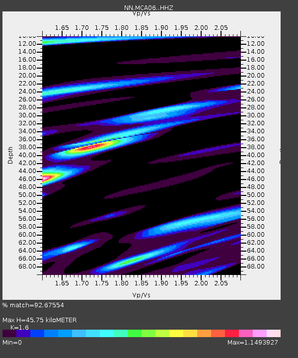
MCA06 Monte Cristo ASL 06 - Earthquake Result Viewer
| Earthquake location: |
Tonga Islands Region |
| Earthquake latitude/longitude: |
-22.2/-174.3 |
| Earthquake time(UTC): |
2020/05/28 (149) 07:18:44 GMT |
| Earthquake Depth: |
10 km |
| Earthquake Magnitude: |
5.9 mww |
| Earthquake Catalog/Contributor: |
NEIC PDE/us |
|
| Network: |
NN Western Great Basin/Eastern Sierra Nevada |
| Station: |
MCA06 Monte Cristo ASL 06 |
| Lat/Lon: |
38.01 N/117.88 W |
| Elevation: |
1462 m |
|
| Distance: |
80.0 deg |
| Az: |
41.927 deg |
| Baz: |
231.604 deg |
| Ray Param: |
0.048607104 |
| Estimated Moho Depth: |
45.75 km |
| Estimated Crust Vp/Vs: |
1.60 |
| Assumed Crust Vp: |
6.276 km/s |
| Estimated Crust Vs: |
3.922 km/s |
| Estimated Crust Poisson's Ratio: |
0.18 |
|
| Radial Match: |
92.67554 % |
| Radial Bump: |
388 |
| Transverse Match: |
87.35617 % |
| Transverse Bump: |
400 |
| SOD ConfigId: |
21166931 |
| Insert Time: |
2020-06-11 07:36:46.225 +0000 |
| GWidth: |
2.5 |
| Max Bumps: |
400 |
| Tol: |
0.001 |
|

Signal To Noise
| Channel | StoN | STA | LTA |
| NN:MCA06: :HHZ:20200528T07:30:22.674998Z | 14.816615 | 1.2401811E-6 | 8.3702055E-8 |
| NN:MCA06: :HHN:20200528T07:30:22.674998Z | 1.9163861 | 1.778351E-7 | 9.2797116E-8 |
| NN:MCA06: :HHE:20200528T07:30:22.674998Z | 5.168643 | 4.3294443E-7 | 8.376365E-8 |
| Arrivals |
| Ps | 4.5 SECOND |
| PpPs | 18 SECOND |
| PsPs/PpSs | 23 SECOND |


