You are here: Home > Network List > KN - Kyrgyz Seismic Telemetry Network Stations List
> Station KZA KN.KZA > Earthquake Result Viewer
KZA KN.KZA - Earthquake Result Viewer

| Earthquake location: |
Bonin Islands, Japan Region |
| Earthquake latitude/longitude: |
28.9/139.6 |
| Earthquake time(UTC): |
2000/08/06 (219) 07:27:12 GMT |
| Earthquake Depth: |
395 km |
| Earthquake Magnitude: |
6.3 MB, 7.3 MW, 7.3 MW |
| Earthquake Catalog/Contributor: |
WHDF/NEIC |
|
| Network: |
KN Kyrgyz Seismic Telemetry Network |
| Station: |
KZA KN.KZA |
| Lat/Lon: |
42.08 N/75.25 E |
| Elevation: |
3520 m |
|
| Distance: |
52.9 deg |
| Az: |
302.701 deg |
| Baz: |
82.539 deg |
| Ray Param: |
0.06491022 |
| Estimated Moho Depth: |
52.25 km |
| Estimated Crust Vp/Vs: |
1.94 |
| Assumed Crust Vp: |
6.306 km/s |
| Estimated Crust Vs: |
3.255 km/s |
| Estimated Crust Poisson's Ratio: |
0.32 |
|
| Radial Match: |
95.20508 % |
| Radial Bump: |
400 |
| Transverse Match: |
91.46672 % |
| Transverse Bump: |
400 |
| SOD ConfigId: |
3744 |
| Insert Time: |
2010-03-08 20:29:06.597 +0000 |
| GWidth: |
2.5 |
| Max Bumps: |
400 |
| Tol: |
0.001 |
|
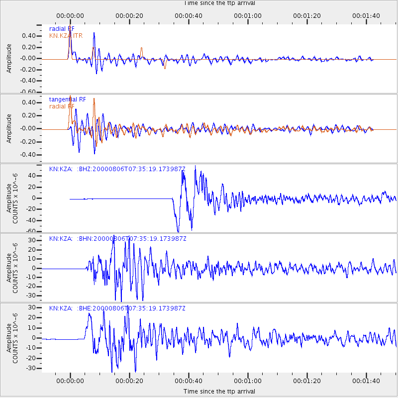
Signal To Noise
| Channel | StoN | STA | LTA |
| KN:KZA: :BHN:20000806T07:35:19.173987Z | 0.95574415 | 4.2104748E-8 | 4.4054413E-8 |
| KN:KZA: :BHE:20000806T07:35:19.173987Z | 2.0406437 | 3.4451602E-7 | 1.6882714E-7 |
| KN:KZA: :BHZ:20000806T07:35:19.173987Z | 3.5277371 | 8.4668613E-7 | 2.400083E-7 |
| Arrivals |
| Ps | 8.1 SECOND |
| PpPs | 23 SECOND |
| PsPs/PpSs | 31 SECOND |


