You are here: Home > Network List > TS - TERRAscope (Southern California Seismic Network) Stations List
> Station SNCC San Nicolas Island, California, USA > Earthquake Result Viewer
SNCC San Nicolas Island, California, USA - Earthquake Result Viewer

| Earthquake location: |
Vanuatu Islands |
| Earthquake latitude/longitude: |
-20.4/169.3 |
| Earthquake time(UTC): |
1997/05/21 (141) 14:10:26 GMT |
| Earthquake Depth: |
57 km |
| Earthquake Magnitude: |
5.9 MB, 6.5 MS, 6.7 UNKNOWN, 6.1 ME |
| Earthquake Catalog/Contributor: |
WHDF/NEIC |
|
| Network: |
TS TERRAscope (Southern California Seismic Network) |
| Station: |
SNCC San Nicolas Island, California, USA |
| Lat/Lon: |
33.25 N/119.52 W |
| Elevation: |
227 m |
|
| Distance: |
86.3 deg |
| Az: |
52.642 deg |
| Baz: |
242.816 deg |
| Ray Param: |
0.044027463 |
| Estimated Moho Depth: |
17.0 km |
| Estimated Crust Vp/Vs: |
1.75 |
| Assumed Crust Vp: |
6.048 km/s |
| Estimated Crust Vs: |
3.466 km/s |
| Estimated Crust Poisson's Ratio: |
0.26 |
|
| Radial Match: |
89.11671 % |
| Radial Bump: |
400 |
| Transverse Match: |
76.1913 % |
| Transverse Bump: |
400 |
| SOD ConfigId: |
6273 |
| Insert Time: |
2010-02-26 14:51:38.132 +0000 |
| GWidth: |
2.5 |
| Max Bumps: |
400 |
| Tol: |
0.001 |
|
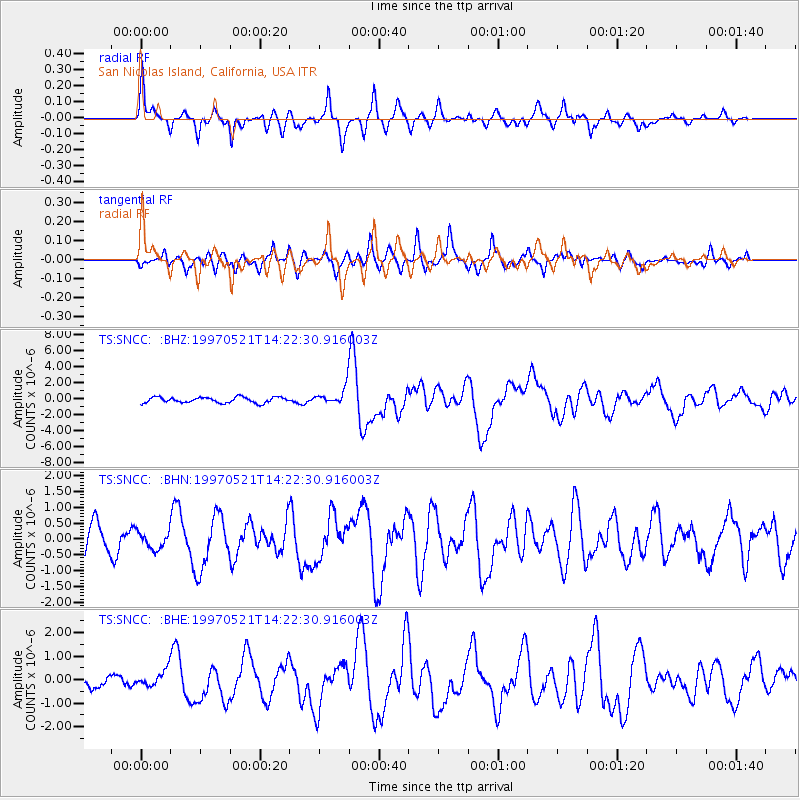
Signal To Noise
| Channel | StoN | STA | LTA |
| TS:SNCC: :BHN:19970521T14:22:30.916003Z | 0.70095986 | 2.7083243E-7 | 3.8637367E-7 |
| TS:SNCC: :BHE:19970521T14:22:30.916003Z | 0.95429355 | 3.622801E-7 | 3.796317E-7 |
| TS:SNCC: :BHZ:19970521T14:22:30.916003Z | 3.0088508 | 1.0597852E-6 | 3.522226E-7 |
| Arrivals |
| Ps | 2.1 SECOND |
| PpPs | 7.6 SECOND |
| PsPs/PpSs | 9.7 SECOND |


