You are here: Home > Network List > TA - USArray Transportable Network (new EarthScope stations) Stations List
> Station C16K Lisburne Hills, AK, USA > Earthquake Result Viewer
C16K Lisburne Hills, AK, USA - Earthquake Result Viewer
| Earthquake location: |
Tonga Islands Region |
| Earthquake latitude/longitude: |
-22.2/-174.3 |
| Earthquake time(UTC): |
2020/05/28 (149) 07:18:44 GMT |
| Earthquake Depth: |
10 km |
| Earthquake Magnitude: |
5.9 mww |
| Earthquake Catalog/Contributor: |
NEIC PDE/us |
|
| Network: |
TA USArray Transportable Network (new EarthScope stations) |
| Station: |
C16K Lisburne Hills, AK, USA |
| Lat/Lon: |
68.27 N/165.34 W |
| Elevation: |
102 m |
|
| Distance: |
90.5 deg |
| Az: |
3.317 deg |
| Baz: |
188.28 deg |
| Ray Param: |
0.041700784 |
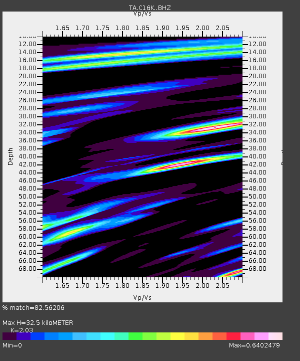
| Estimated Moho Depth: |
32.5 km |
| Estimated Crust Vp/Vs: |
2.03 |
| Assumed Crust Vp: |
5.906 km/s |
| Estimated Crust Vs: |
2.91 km/s |
| Estimated Crust Poisson's Ratio: |
0.34 |
|
| Radial Match: |
82.56206 % |
| Radial Bump: |
400 |
| Transverse Match: |
78.38316 % |
| Transverse Bump: |
400 |
| SOD ConfigId: |
21166931 |
| Insert Time: |
2020-06-11 07:41:14.518 +0000 |
| GWidth: |
2.5 |
| Max Bumps: |
400 |
| Tol: |
0.001 |
|
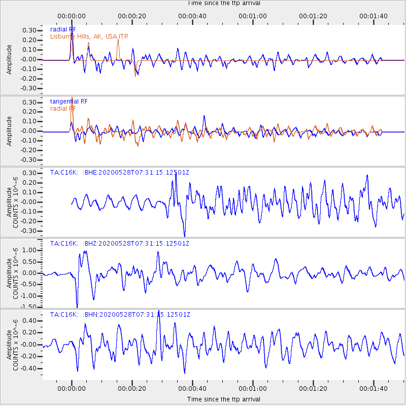
Signal To Noise
| Channel | StoN | STA | LTA |
| TA:C16K: :BHZ:20200528T07:31:15.12501Z | 9.825474 | 6.598108E-7 | 6.7153074E-8 |
| TA:C16K: :BHN:20200528T07:31:15.12501Z | 4.088849 | 1.8151398E-7 | 4.4392436E-8 |
| TA:C16K: :BHE:20200528T07:31:15.12501Z | 2.5309784 | 1.1556303E-7 | 4.565943E-8 |
| Arrivals |
| Ps | 5.8 SECOND |
| PpPs | 16 SECOND |
| PsPs/PpSs | 22 SECOND |


