You are here: Home > Network List > TA - USArray Transportable Network (new EarthScope stations) Stations List
> Station H18K Honhosa River, AK, USA > Earthquake Result Viewer
H18K Honhosa River, AK, USA - Earthquake Result Viewer
| Earthquake location: |
Tonga Islands Region |
| Earthquake latitude/longitude: |
-22.2/-174.3 |
| Earthquake time(UTC): |
2020/05/28 (149) 07:18:44 GMT |
| Earthquake Depth: |
10 km |
| Earthquake Magnitude: |
5.9 mww |
| Earthquake Catalog/Contributor: |
NEIC PDE/us |
|
| Network: |
TA USArray Transportable Network (new EarthScope stations) |
| Station: |
H18K Honhosa River, AK, USA |
| Lat/Lon: |
65.15 N/158.36 W |
| Elevation: |
494 m |
|
| Distance: |
88.0 deg |
| Az: |
6.66 deg |
| Baz: |
194.734 deg |
| Ray Param: |
0.04293841 |
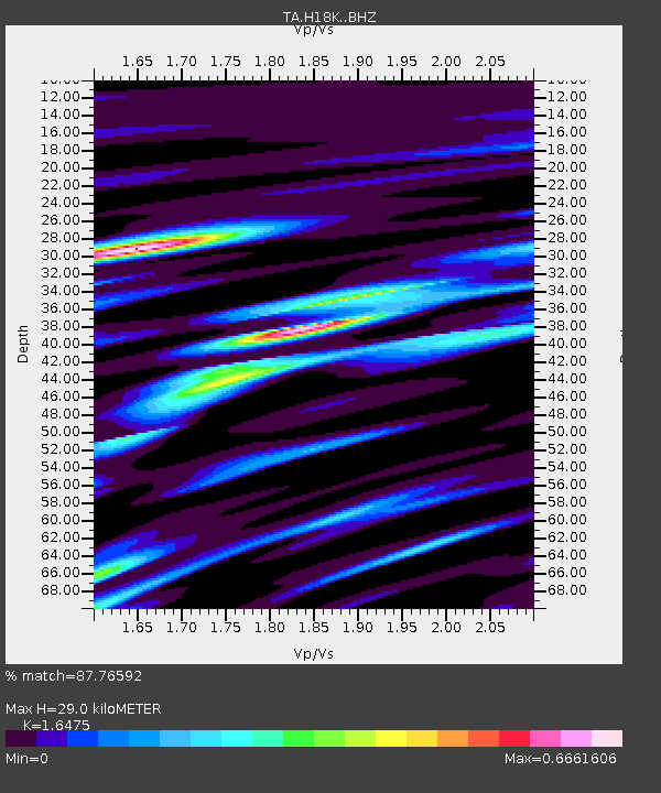
| Estimated Moho Depth: |
29.0 km |
| Estimated Crust Vp/Vs: |
1.65 |
| Assumed Crust Vp: |
6.1 km/s |
| Estimated Crust Vs: |
3.703 km/s |
| Estimated Crust Poisson's Ratio: |
0.21 |
|
| Radial Match: |
87.76592 % |
| Radial Bump: |
400 |
| Transverse Match: |
85.82886 % |
| Transverse Bump: |
400 |
| SOD ConfigId: |
21166931 |
| Insert Time: |
2020-06-11 07:42:37.265 +0000 |
| GWidth: |
2.5 |
| Max Bumps: |
400 |
| Tol: |
0.001 |
|

Signal To Noise
| Channel | StoN | STA | LTA |
| TA:H18K: :BHZ:20200528T07:31:03.349986Z | 10.882814 | 8.108613E-7 | 7.450842E-8 |
| TA:H18K: :BHN:20200528T07:31:03.349986Z | 5.1988125 | 2.4630788E-7 | 4.7377718E-8 |
| TA:H18K: :BHE:20200528T07:31:03.349986Z | 3.04384 | 1.6101707E-7 | 5.289932E-8 |
| Arrivals |
| Ps | 3.1 SECOND |
| PpPs | 12 SECOND |
| PsPs/PpSs | 15 SECOND |


