You are here: Home > Network List > TA - USArray Transportable Network (new EarthScope stations) Stations List
> Station N15K Kwethluk River, AK, USA > Earthquake Result Viewer
N15K Kwethluk River, AK, USA - Earthquake Result Viewer
| Earthquake location: |
Tonga Islands Region |
| Earthquake latitude/longitude: |
-22.2/-174.3 |
| Earthquake time(UTC): |
2020/05/28 (149) 07:18:44 GMT |
| Earthquake Depth: |
10 km |
| Earthquake Magnitude: |
5.9 mww |
| Earthquake Catalog/Contributor: |
NEIC PDE/us |
|
| Network: |
TA USArray Transportable Network (new EarthScope stations) |
| Station: |
N15K Kwethluk River, AK, USA |
| Lat/Lon: |
60.17 N/160.09 W |
| Elevation: |
449 m |
|
| Distance: |
82.9 deg |
| Az: |
7.096 deg |
| Baz: |
193.233 deg |
| Ray Param: |
0.046556532 |
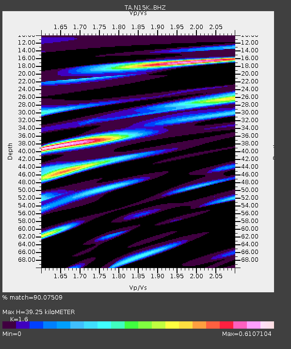
| Estimated Moho Depth: |
39.25 km |
| Estimated Crust Vp/Vs: |
1.60 |
| Assumed Crust Vp: |
6.182 km/s |
| Estimated Crust Vs: |
3.864 km/s |
| Estimated Crust Poisson's Ratio: |
0.18 |
|
| Radial Match: |
90.07509 % |
| Radial Bump: |
400 |
| Transverse Match: |
83.954834 % |
| Transverse Bump: |
400 |
| SOD ConfigId: |
21166931 |
| Insert Time: |
2020-06-11 07:43:30.015 +0000 |
| GWidth: |
2.5 |
| Max Bumps: |
400 |
| Tol: |
0.001 |
|

Signal To Noise
| Channel | StoN | STA | LTA |
| TA:N15K: :BHZ:20200528T07:30:38.274974Z | 15.906098 | 1.3024787E-6 | 8.188549E-8 |
| TA:N15K: :BHN:20200528T07:30:38.274974Z | 9.093196 | 4.909106E-7 | 5.3986586E-8 |
| TA:N15K: :BHE:20200528T07:30:38.274974Z | 2.5731542 | 2.3543606E-7 | 9.149707E-8 |
| Arrivals |
| Ps | 3.9 SECOND |
| PpPs | 16 SECOND |
| PsPs/PpSs | 20 SECOND |


