You are here: Home > Network List > TD - TransAlta Monitoring Network Stations List
> Station TD011 Z > Earthquake Result Viewer
TD011 Z - Earthquake Result Viewer
| Earthquake location: |
Tonga Islands Region |
| Earthquake latitude/longitude: |
-22.2/-174.3 |
| Earthquake time(UTC): |
2020/05/28 (149) 07:18:44 GMT |
| Earthquake Depth: |
10 km |
| Earthquake Magnitude: |
5.9 mww |
| Earthquake Catalog/Contributor: |
NEIC PDE/us |
|
| Network: |
TD TransAlta Monitoring Network |
| Station: |
TD011 Z |
| Lat/Lon: |
52.55 N/115.52 W |
| Elevation: |
1103 m |
|
| Distance: |
90.3 deg |
| Az: |
31.478 deg |
| Baz: |
232.397 deg |
| Ray Param: |
0.041714337 |
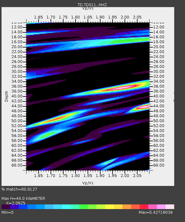
| Estimated Moho Depth: |
44.0 km |
| Estimated Crust Vp/Vs: |
2.09 |
| Assumed Crust Vp: |
6.426 km/s |
| Estimated Crust Vs: |
3.071 km/s |
| Estimated Crust Poisson's Ratio: |
0.35 |
|
| Radial Match: |
80.8127 % |
| Radial Bump: |
400 |
| Transverse Match: |
63.892788 % |
| Transverse Bump: |
400 |
| SOD ConfigId: |
21166931 |
| Insert Time: |
2020-06-11 07:44:26.065 +0000 |
| GWidth: |
2.5 |
| Max Bumps: |
400 |
| Tol: |
0.001 |
|

Signal To Noise
| Channel | StoN | STA | LTA |
| TD:TD011: :HHZ:20200528T07:31:14.089976Z | 23.598688 | 1.3443906E-6 | 5.6968872E-8 |
| TD:TD011: :HH1:20200528T07:31:14.089976Z | 3.4814038 | 2.5145454E-7 | 7.222791E-8 |
| TD:TD011: :HH2:20200528T07:31:14.089976Z | 0.9481471 | 9.888205E-8 | 1.04289775E-7 |
| Arrivals |
| Ps | 7.6 SECOND |
| PpPs | 21 SECOND |
| PsPs/PpSs | 28 SECOND |


