You are here: Home > Network List > TX - Texas Seismological Network Stations List
> Station DRIO Del Rio > Earthquake Result Viewer
DRIO Del Rio - Earthquake Result Viewer
| Earthquake location: |
Tonga Islands Region |
| Earthquake latitude/longitude: |
-22.2/-174.3 |
| Earthquake time(UTC): |
2020/05/28 (149) 07:18:44 GMT |
| Earthquake Depth: |
10 km |
| Earthquake Magnitude: |
5.9 mww |
| Earthquake Catalog/Contributor: |
NEIC PDE/us |
|
| Network: |
TX Texas Seismological Network |
| Station: |
DRIO Del Rio |
| Lat/Lon: |
29.42 N/100.62 W |
| Elevation: |
354 m |
|
| Distance: |
87.5 deg |
| Az: |
56.93 deg |
| Baz: |
242.869 deg |
| Ray Param: |
0.043274954 |
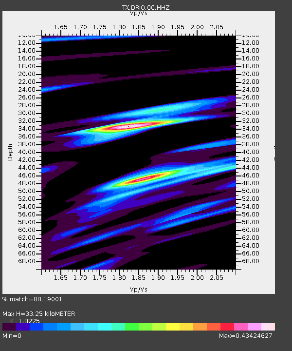
| Estimated Moho Depth: |
33.25 km |
| Estimated Crust Vp/Vs: |
1.82 |
| Assumed Crust Vp: |
6.12 km/s |
| Estimated Crust Vs: |
3.358 km/s |
| Estimated Crust Poisson's Ratio: |
0.28 |
|
| Radial Match: |
88.19001 % |
| Radial Bump: |
301 |
| Transverse Match: |
71.22336 % |
| Transverse Bump: |
400 |
| SOD ConfigId: |
21166931 |
| Insert Time: |
2020-06-11 07:44:52.735 +0000 |
| GWidth: |
2.5 |
| Max Bumps: |
400 |
| Tol: |
0.001 |
|

Signal To Noise
| Channel | StoN | STA | LTA |
| TX:DRIO:00:HHZ:20200528T07:31:01.154979Z | 21.345325 | 1.3100162E-6 | 6.137251E-8 |
| TX:DRIO:00:HH1:20200528T07:31:01.154979Z | 5.065929 | 2.5655643E-7 | 5.064351E-8 |
| TX:DRIO:00:HH2:20200528T07:31:01.154979Z | 5.4654784 | 4.4147734E-7 | 8.077561E-8 |
| Arrivals |
| Ps | 4.6 SECOND |
| PpPs | 15 SECOND |
| PsPs/PpSs | 20 SECOND |


