You are here: Home > Network List > TX - Texas Seismological Network Stations List
> Station MB07 West Midland > Earthquake Result Viewer
MB07 West Midland - Earthquake Result Viewer
| Earthquake location: |
Tonga Islands Region |
| Earthquake latitude/longitude: |
-22.2/-174.3 |
| Earthquake time(UTC): |
2020/05/28 (149) 07:18:44 GMT |
| Earthquake Depth: |
10 km |
| Earthquake Magnitude: |
5.9 mww |
| Earthquake Catalog/Contributor: |
NEIC PDE/us |
|
| Network: |
TX Texas Seismological Network |
| Station: |
MB07 West Midland |
| Lat/Lon: |
32.00 N/102.25 W |
| Elevation: |
880 m |
|
| Distance: |
87.5 deg |
| Az: |
53.998 deg |
| Baz: |
241.909 deg |
| Ray Param: |
0.043315005 |
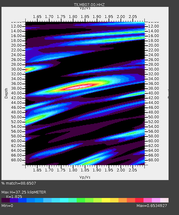
| Estimated Moho Depth: |
37.25 km |
| Estimated Crust Vp/Vs: |
1.83 |
| Assumed Crust Vp: |
6.129 km/s |
| Estimated Crust Vs: |
3.358 km/s |
| Estimated Crust Poisson's Ratio: |
0.29 |
|
| Radial Match: |
88.6507 % |
| Radial Bump: |
400 |
| Transverse Match: |
77.62633 % |
| Transverse Bump: |
400 |
| SOD ConfigId: |
21166931 |
| Insert Time: |
2020-06-11 07:45:22.511 +0000 |
| GWidth: |
2.5 |
| Max Bumps: |
400 |
| Tol: |
0.001 |
|

Signal To Noise
| Channel | StoN | STA | LTA |
| TX:MB07:00:HHZ:20200528T07:31:00.890025Z | 13.027944 | 5.755491E-7 | 4.4178048E-8 |
| TX:MB07:00:HH1:20200528T07:31:00.890025Z | 1.9747418 | 7.612119E-8 | 3.8547412E-8 |
| TX:MB07:00:HH2:20200528T07:31:00.890025Z | 2.9817846 | 1.602847E-7 | 5.375462E-8 |
| Arrivals |
| Ps | 5.1 SECOND |
| PpPs | 17 SECOND |
| PsPs/PpSs | 22 SECOND |


