You are here: Home > Network List > TX - Texas Seismological Network Stations List
> Station PB21 Reeves Ward Border > Earthquake Result Viewer
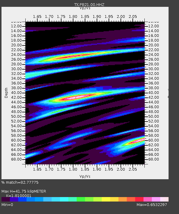
PB21 Reeves Ward Border - Earthquake Result Viewer
| Earthquake location: |
Tonga Islands Region |
| Earthquake latitude/longitude: |
-22.2/-174.3 |
| Earthquake time(UTC): |
2020/05/28 (149) 07:18:44 GMT |
| Earthquake Depth: |
10 km |
| Earthquake Magnitude: |
5.9 mww |
| Earthquake Catalog/Contributor: |
NEIC PDE/us |
|
| Network: |
TX Texas Seismological Network |
| Station: |
PB21 Reeves Ward Border |
| Lat/Lon: |
31.34 N/103.06 W |
| Elevation: |
753 m |
|
| Distance: |
86.5 deg |
| Az: |
54.25 deg |
| Baz: |
241.5 deg |
| Ray Param: |
0.04398328 |
| Estimated Moho Depth: |
41.75 km |
| Estimated Crust Vp/Vs: |
1.81 |
| Assumed Crust Vp: |
6.121 km/s |
| Estimated Crust Vs: |
3.381 km/s |
| Estimated Crust Poisson's Ratio: |
0.28 |
|
| Radial Match: |
82.77775 % |
| Radial Bump: |
400 |
| Transverse Match: |
71.09937 % |
| Transverse Bump: |
400 |
| SOD ConfigId: |
21166931 |
| Insert Time: |
2020-06-11 07:45:46.585 +0000 |
| GWidth: |
2.5 |
| Max Bumps: |
400 |
| Tol: |
0.001 |
|

Signal To Noise
| Channel | StoN | STA | LTA |
| TX:PB21:00:HHZ:20200528T07:30:56.430003Z | 5.5251737 | 9.493184E-7 | 1.7181694E-7 |
| TX:PB21:00:HH1:20200528T07:30:56.430003Z | 1.1957448 | 1.7537583E-7 | 1.4666661E-7 |
| TX:PB21:00:HH2:20200528T07:30:56.430003Z | 4.6137695 | 2.7929417E-7 | 6.0534916E-8 |
| Arrivals |
| Ps | 5.6 SECOND |
| PpPs | 19 SECOND |
| PsPs/PpSs | 24 SECOND |


