You are here: Home > Network List > UO - University of Oregon Regional Network Stations List
> Station SISQ Selma, OR, USA > Earthquake Result Viewer
SISQ Selma, OR, USA - Earthquake Result Viewer
| Earthquake location: |
Tonga Islands Region |
| Earthquake latitude/longitude: |
-22.2/-174.3 |
| Earthquake time(UTC): |
2020/05/28 (149) 07:18:44 GMT |
| Earthquake Depth: |
10 km |
| Earthquake Magnitude: |
5.9 mww |
| Earthquake Catalog/Contributor: |
NEIC PDE/us |
|
| Network: |
UO University of Oregon Regional Network |
| Station: |
SISQ Selma, OR, USA |
| Lat/Lon: |
42.28 N/123.63 W |
| Elevation: |
395 m |
|
| Distance: |
79.4 deg |
| Az: |
35.724 deg |
| Baz: |
226.795 deg |
| Ray Param: |
0.048986517 |
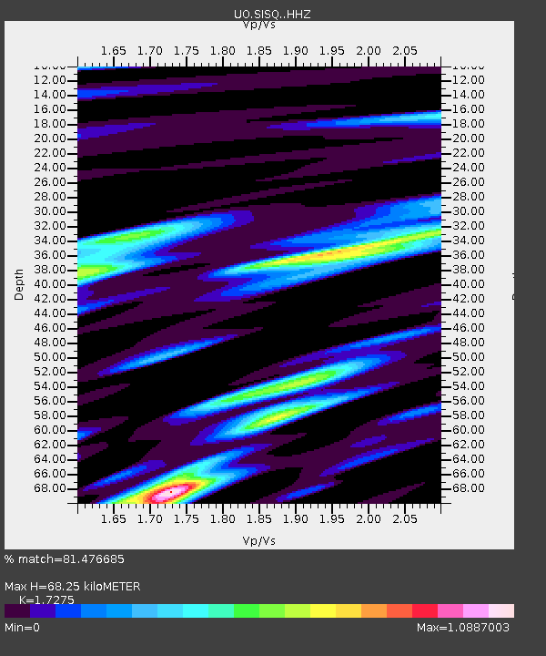
| Estimated Moho Depth: |
68.25 km |
| Estimated Crust Vp/Vs: |
1.73 |
| Assumed Crust Vp: |
6.522 km/s |
| Estimated Crust Vs: |
3.775 km/s |
| Estimated Crust Poisson's Ratio: |
0.25 |
|
| Radial Match: |
81.476685 % |
| Radial Bump: |
400 |
| Transverse Match: |
65.99629 % |
| Transverse Bump: |
400 |
| SOD ConfigId: |
21166931 |
| Insert Time: |
2020-06-11 07:46:54.988 +0000 |
| GWidth: |
2.5 |
| Max Bumps: |
400 |
| Tol: |
0.001 |
|

Signal To Noise
| Channel | StoN | STA | LTA |
| UO:SISQ: :HHZ:20200528T07:30:19.669993Z | 7.2727394 | 9.723248E-7 | 1.3369443E-7 |
| UO:SISQ: :HHN:20200528T07:30:19.669993Z | 1.8239459 | 1.8247977E-7 | 1.000467E-7 |
| UO:SISQ: :HHE:20200528T07:30:19.669993Z | 1.0967648 | 1.6731147E-7 | 1.5255E-7 |
| Arrivals |
| Ps | 7.9 SECOND |
| PpPs | 28 SECOND |
| PsPs/PpSs | 36 SECOND |


