You are here: Home > Network List > US - United States National Seismic Network Stations List
> Station WMOK Wichita Mountains, Oklahoma, USA > Earthquake Result Viewer
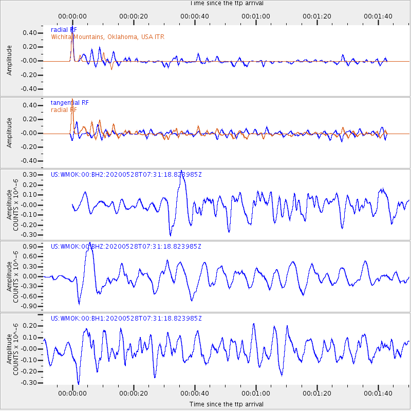
WMOK Wichita Mountains, Oklahoma, USA - Earthquake Result Viewer
*The percent match for this event was below the threshold and hence no stack was calculated.
| Earthquake location: |
Tonga Islands Region |
| Earthquake latitude/longitude: |
-22.2/-174.3 |
| Earthquake time(UTC): |
2020/05/28 (149) 07:18:44 GMT |
| Earthquake Depth: |
10 km |
| Earthquake Magnitude: |
5.9 mww |
| Earthquake Catalog/Contributor: |
NEIC PDE/us |
|
| Network: |
US United States National Seismic Network |
| Station: |
WMOK Wichita Mountains, Oklahoma, USA |
| Lat/Lon: |
34.74 N/98.78 W |
| Elevation: |
486 m |
|
| Distance: |
91.3 deg |
| Az: |
52.896 deg |
| Baz: |
243.799 deg |
| Ray Param: |
$rayparam |
*The percent match for this event was below the threshold and hence was not used in the summary stack. |
|
| Radial Match: |
78.901024 % |
| Radial Bump: |
400 |
| Transverse Match: |
59.157948 % |
| Transverse Bump: |
400 |
| SOD ConfigId: |
21166931 |
| Insert Time: |
2020-06-11 07:47:49.005 +0000 |
| GWidth: |
2.5 |
| Max Bumps: |
400 |
| Tol: |
0.001 |
|
Signal To Noise
| Channel | StoN | STA | LTA |
| US:WMOK:00:BHZ:20200528T07:31:18.823985Z | 7.655749 | 4.1786038E-7 | 5.4581253E-8 |
| US:WMOK:00:BH1:20200528T07:31:18.823985Z | 2.3953745 | 1.5938336E-7 | 6.653798E-8 |
| US:WMOK:00:BH2:20200528T07:31:18.823985Z | 3.2837684 | 1.4928874E-7 | 4.546263E-8 |
| Arrivals |
| Ps | |
| PpPs | |
| PsPs/PpSs | |


