You are here: Home > Network List > GS - US Geological Survey Networks Stations List
> Station KAN08 Pence Farm, Harper, KS, USA > Earthquake Result Viewer
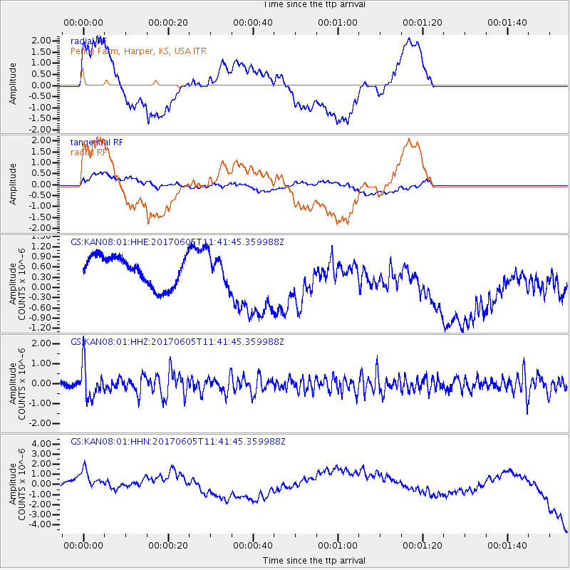
KAN08 Pence Farm, Harper, KS, USA - Earthquake Result Viewer
*The percent match for this event was below the threshold and hence no stack was calculated.
| Earthquake location: |
Peru-Ecuador Border Region |
| Earthquake latitude/longitude: |
-4.1/-80.4 |
| Earthquake time(UTC): |
2017/06/05 (156) 11:34:11 GMT |
| Earthquake Depth: |
51 km |
| Earthquake Magnitude: |
5.6 Mww |
| Earthquake Catalog/Contributor: |
NEIC PDE/us |
|
| Network: |
GS US Geological Survey Networks |
| Station: |
KAN08 Pence Farm, Harper, KS, USA |
| Lat/Lon: |
37.23 N/97.97 W |
| Elevation: |
375 m |
|
| Distance: |
44.3 deg |
| Az: |
339.784 deg |
| Baz: |
154.417 deg |
| Ray Param: |
$rayparam |
*The percent match for this event was below the threshold and hence was not used in the summary stack. |
|
| Radial Match: |
26.392328 % |
| Radial Bump: |
400 |
| Transverse Match: |
10.905164 % |
| Transverse Bump: |
400 |
| SOD ConfigId: |
2140511 |
| Insert Time: |
2017-06-19 03:26:54.433 +0000 |
| GWidth: |
2.5 |
| Max Bumps: |
400 |
| Tol: |
0.001 |
|
Signal To Noise
| Channel | StoN | STA | LTA |
| GS:KAN08:01:HHZ:20170605T11:41:45.359988Z | 6.897308 | 8.5224474E-7 | 1.2356195E-7 |
| GS:KAN08:01:HHN:20170605T11:41:45.359988Z | 2.1620681 | 1.8716007E-6 | 8.6565296E-7 |
| GS:KAN08:01:HHE:20170605T11:41:45.359988Z | 1.0087272 | 4.3131598E-7 | 4.2758438E-7 |
| Arrivals |
| Ps | |
| PpPs | |
| PsPs/PpSs | |


