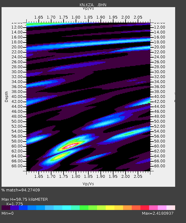
KZA KN.KZA - Earthquake Result Viewer
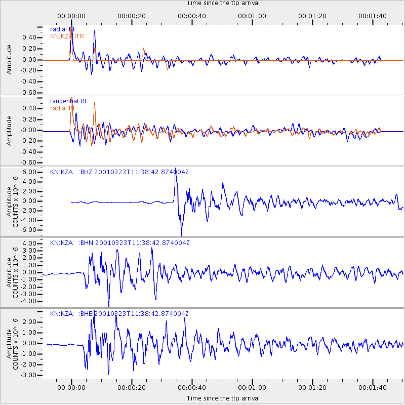
Earthquake location: Kuril Islands
Earthquake latitude/longitude: 44.1/148.1
Earthquake time(UTC): 2001/03/23 (082) 11:30:10 GMT
Earthquake Depth: 33 km
Earthquake Magnitude: 5.9 MB, 5.7 MS, 6.0 MW, 5.9 MW
Earthquake Catalog/Contributor: WHDF/NEIC
Network: KN Kyrgyz Seismic Telemetry Network
Station: KZA KN.KZA
Lat/Lon: 42.08 N/75.25 E
Elevation: 3520 m
Distance: 51.6 deg
Az: 294.806 deg
Baz: 61.508 deg
Ray Param: 0.06725845
Estimated Moho Depth: 59.75 km
Estimated Crust Vp/Vs: 1.77
Assumed Crust Vp: 6.306 km/s
Estimated Crust Vs: 3.553 km/s
Estimated Crust Poisson's Ratio: 0.27
Radial Match: 94.27409 %
Radial Bump: 400
Transverse Match: 85.952866 %
Transverse Bump: 400
SOD ConfigId: 4714
Insert Time: 2010-03-08 20:30:50.253 +0000
GWidth: 2.5
Max Bumps: 400
Tol: 0.001

Signal To Noise

ChannelStoNSTALTA
KN:KZA: :BHN:20010323T11:38:42.874004Z1.95627364.3676562E-72.2326408E-7
KN:KZA: :BHE:20010323T11:38:42.874004Z8.3885595.9431306E-77.084805E-8
KN:KZA: :BHZ:20010323T11:38:42.874004Z24.4404811.8969162E-67.76137E-8
Arrivals
Ps7.8 SECOND
PpPs25 SECOND
PsPs/PpSs33 SECOND