You are here: Home > Network List > UU - University of Utah Regional Network Stations List
> Station TCRU Three Creek Reservoir, UT, USA > Earthquake Result Viewer
TCRU Three Creek Reservoir, UT, USA - Earthquake Result Viewer
| Earthquake location: |
Tonga Islands Region |
| Earthquake latitude/longitude: |
-22.2/-174.3 |
| Earthquake time(UTC): |
2020/05/28 (149) 07:18:44 GMT |
| Earthquake Depth: |
10 km |
| Earthquake Magnitude: |
5.9 mww |
| Earthquake Catalog/Contributor: |
NEIC PDE/us |
|
| Network: |
UU University of Utah Regional Network |
| Station: |
TCRU Three Creek Reservoir, UT, USA |
| Lat/Lon: |
38.61 N/112.45 W |
| Elevation: |
2293 m |
|
| Distance: |
83.8 deg |
| Az: |
44.014 deg |
| Baz: |
235.256 deg |
| Ray Param: |
0.045965042 |
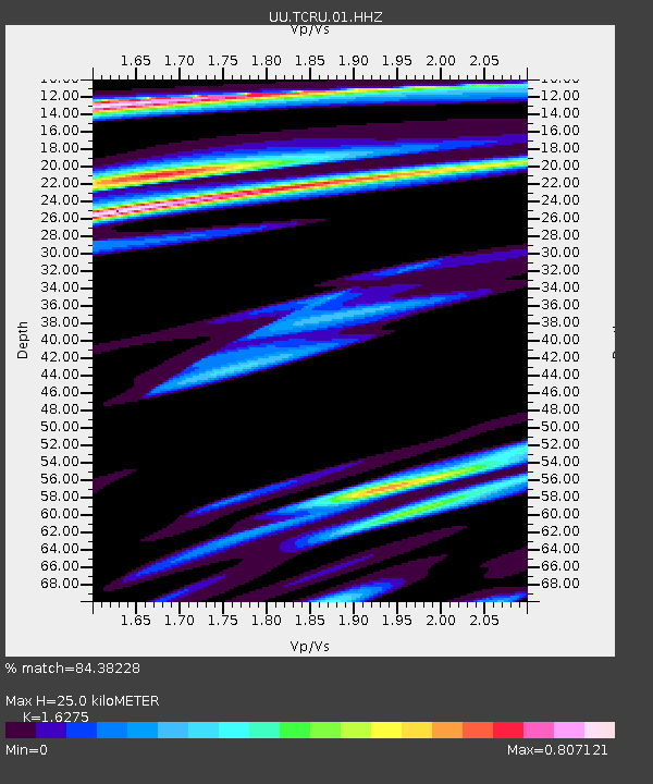
| Estimated Moho Depth: |
25.0 km |
| Estimated Crust Vp/Vs: |
1.63 |
| Assumed Crust Vp: |
6.276 km/s |
| Estimated Crust Vs: |
3.856 km/s |
| Estimated Crust Poisson's Ratio: |
0.20 |
|
| Radial Match: |
84.38228 % |
| Radial Bump: |
400 |
| Transverse Match: |
88.94996 % |
| Transverse Bump: |
400 |
| SOD ConfigId: |
21166931 |
| Insert Time: |
2020-06-11 07:48:41.185 +0000 |
| GWidth: |
2.5 |
| Max Bumps: |
400 |
| Tol: |
0.001 |
|

Signal To Noise
| Channel | StoN | STA | LTA |
| UU:TCRU:01:HHZ:20200528T07:30:42.560008Z | 9.085947 | 3.010701E-8 | 3.3135794E-9 |
| UU:TCRU:01:HHN:20200528T07:30:42.560008Z | 5.3710914 | 8.053307E-9 | 1.49938E-9 |
| UU:TCRU:01:HHE:20200528T07:30:42.560008Z | 2.8153934 | 6.8152644E-9 | 2.4207145E-9 |
| Arrivals |
| Ps | 2.6 SECOND |
| PpPs | 10 SECOND |
| PsPs/PpSs | 13 SECOND |


