You are here: Home > Network List > WY - Yellowstone Wyoming Seismic Network Stations List
> Station YHB Horse Butte YNP, MT, USA > Earthquake Result Viewer
YHB Horse Butte YNP, MT, USA - Earthquake Result Viewer
| Earthquake location: |
Tonga Islands Region |
| Earthquake latitude/longitude: |
-22.2/-174.3 |
| Earthquake time(UTC): |
2020/05/28 (149) 07:18:44 GMT |
| Earthquake Depth: |
10 km |
| Earthquake Magnitude: |
5.9 mww |
| Earthquake Catalog/Contributor: |
NEIC PDE/us |
|
| Network: |
WY Yellowstone Wyoming Seismic Network |
| Station: |
YHB Horse Butte YNP, MT, USA |
| Lat/Lon: |
44.75 N/111.20 W |
| Elevation: |
2167 m |
|
| Distance: |
88.0 deg |
| Az: |
39.476 deg |
| Baz: |
235.76 deg |
| Ray Param: |
0.042911265 |
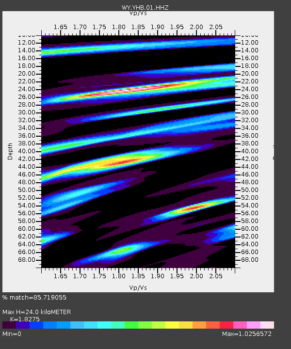
| Estimated Moho Depth: |
24.0 km |
| Estimated Crust Vp/Vs: |
1.83 |
| Assumed Crust Vp: |
6.35 km/s |
| Estimated Crust Vs: |
3.475 km/s |
| Estimated Crust Poisson's Ratio: |
0.29 |
|
| Radial Match: |
85.719055 % |
| Radial Bump: |
386 |
| Transverse Match: |
79.56964 % |
| Transverse Bump: |
400 |
| SOD ConfigId: |
21166931 |
| Insert Time: |
2020-06-11 07:50:31.129 +0000 |
| GWidth: |
2.5 |
| Max Bumps: |
400 |
| Tol: |
0.001 |
|

Signal To Noise
| Channel | StoN | STA | LTA |
| WY:YHB:01:HHZ:20200528T07:31:03.524974Z | 7.256471 | 1.7692406E-8 | 2.4381557E-9 |
| WY:YHB:01:HHN:20200528T07:31:03.524974Z | 2.7078006 | 5.3749987E-9 | 1.9850053E-9 |
| WY:YHB:01:HHE:20200528T07:31:03.524974Z | 2.0051434 | 5.1304343E-9 | 2.5586369E-9 |
| Arrivals |
| Ps | 3.2 SECOND |
| PpPs | 10 SECOND |
| PsPs/PpSs | 14 SECOND |


