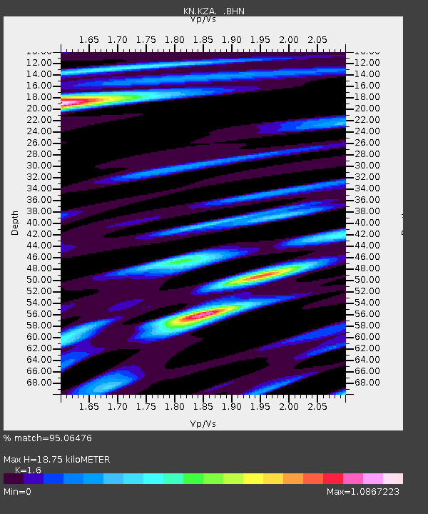
KZA KN.KZA - Earthquake Result Viewer
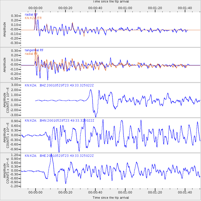
Earthquake location: Solomon Islands
Earthquake latitude/longitude: -7.0/155.0
Earthquake time(UTC): 2001/05/29 (149) 23:37:19 GMT
Earthquake Depth: 14 km
Earthquake Magnitude: 5.7 MB, 6.4 MS, 6.4 MW, 5.7 ME
Earthquake Catalog/Contributor: WHDF/NEIC
Network: KN Kyrgyz Seismic Telemetry Network
Station: KZA KN.KZA
Lat/Lon: 42.08 N/75.25 E
Elevation: 3520 m
Distance: 87.1 deg
Az: 312.812 deg
Baz: 102.015 deg
Ray Param: 0.043533444
Estimated Moho Depth: 18.75 km
Estimated Crust Vp/Vs: 1.60
Assumed Crust Vp: 6.306 km/s
Estimated Crust Vs: 3.941 km/s
Estimated Crust Poisson's Ratio: 0.18
Radial Match: 95.06476 %
Radial Bump: 400
Transverse Match: 92.79921 %
Transverse Bump: 400
SOD ConfigId: 4714
Insert Time: 2010-03-08 20:31:17.806 +0000
GWidth: 2.5
Max Bumps: 400
Tol: 0.001

Signal To Noise

ChannelStoNSTALTA
KN:KZA: :BHN:20010529T23:49:33.325022Z1.03456564.7956593E-84.6354327E-8
KN:KZA: :BHE:20010529T23:49:33.325022Z1.07356944.142043E-83.8581977E-8
KN:KZA: :BHZ:20010529T23:49:33.325022Z1.88763881.076953E-75.705292E-8
Arrivals
Ps1.8 SECOND
PpPs7.5 SECOND
PsPs/PpSs9.4 SECOND