You are here: Home > Network List > GS - US Geological Survey Networks Stations List
> Station OK031 S. Brethren Rd., Cushing, OK, USA > Earthquake Result Viewer
OK031 S. Brethren Rd., Cushing, OK, USA - Earthquake Result Viewer
| Earthquake location: |
Peru-Ecuador Border Region |
| Earthquake latitude/longitude: |
-4.1/-80.4 |
| Earthquake time(UTC): |
2017/06/05 (156) 11:34:11 GMT |
| Earthquake Depth: |
51 km |
| Earthquake Magnitude: |
5.6 Mww |
| Earthquake Catalog/Contributor: |
NEIC PDE/us |
|
| Network: |
GS US Geological Survey Networks |
| Station: |
OK031 S. Brethren Rd., Cushing, OK, USA |
| Lat/Lon: |
35.95 N/96.84 W |
| Elevation: |
290 m |
|
| Distance: |
42.7 deg |
| Az: |
340.2 deg |
| Baz: |
155.39 deg |
| Ray Param: |
0.072866134 |
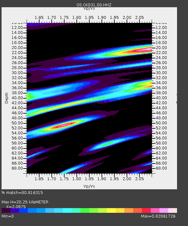
| Estimated Moho Depth: |
20.25 km |
| Estimated Crust Vp/Vs: |
2.10 |
| Assumed Crust Vp: |
6.426 km/s |
| Estimated Crust Vs: |
3.064 km/s |
| Estimated Crust Poisson's Ratio: |
0.35 |
|
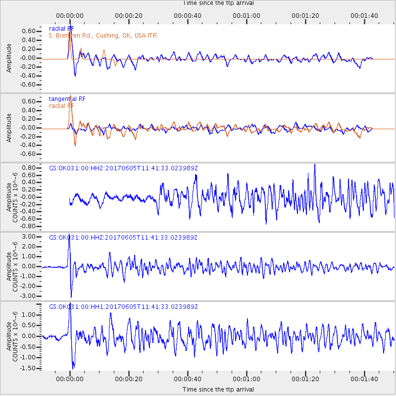
| Radial Match: |
80.816315 % |
| Radial Bump: |
400 |
| Transverse Match: |
67.604355 % |
| Transverse Bump: |
400 |
| SOD ConfigId: |
2140511 |
| Insert Time: |
2017-06-19 03:27:22.932 +0000 |
| GWidth: |
2.5 |
| Max Bumps: |
400 |
| Tol: |
0.001 |
|
Signal To Noise
| Channel | StoN | STA | LTA |
| GS:OK031:00:HHZ:20170605T11:41:33.023989Z | 28.842758 | 1.265322E-6 | 4.386966E-8 |
| GS:OK031:00:HH1:20170605T11:41:33.023989Z | 12.208563 | 7.482693E-7 | 6.129053E-8 |
| GS:OK031:00:HH2:20170605T11:41:33.023989Z | 2.4839375 | 2.1861213E-7 | 8.801032E-8 |
| Arrivals |
| Ps | 3.7 SECOND |
| PpPs | 9.2 SECOND |
| PsPs/PpSs | 13 SECOND |


