You are here: Home > Network List > KN - Kyrgyz Seismic Telemetry Network Stations List
> Station KZA KN.KZA > Earthquake Result Viewer
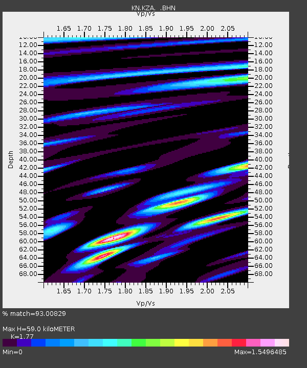
KZA KN.KZA - Earthquake Result Viewer
| Earthquake location: |
Hokkaido, Japan Region |
| Earthquake latitude/longitude: |
43.0/143.8 |
| Earthquake time(UTC): |
1999/05/12 (132) 17:59:22 GMT |
| Earthquake Depth: |
103 km |
| Earthquake Magnitude: |
5.9 MB, 6.2 MW, 6.1 MW |
| Earthquake Catalog/Contributor: |
WHDF/NEIC |
|
| Network: |
KN Kyrgyz Seismic Telemetry Network |
| Station: |
KZA KN.KZA |
| Lat/Lon: |
42.08 N/75.25 E |
| Elevation: |
3520 m |
|
| Distance: |
49.2 deg |
| Az: |
293.735 deg |
| Baz: |
64.373 deg |
| Ray Param: |
0.06851473 |
| Estimated Moho Depth: |
59.0 km |
| Estimated Crust Vp/Vs: |
1.77 |
| Assumed Crust Vp: |
6.306 km/s |
| Estimated Crust Vs: |
3.563 km/s |
| Estimated Crust Poisson's Ratio: |
0.27 |
|
| Radial Match: |
93.00829 % |
| Radial Bump: |
400 |
| Transverse Match: |
92.847466 % |
| Transverse Bump: |
400 |
| SOD ConfigId: |
4480 |
| Insert Time: |
2010-03-08 20:31:42.668 +0000 |
| GWidth: |
2.5 |
| Max Bumps: |
400 |
| Tol: |
0.001 |
|

Signal To Noise
| Channel | StoN | STA | LTA |
| KN:KZA: :BHN:19990512T18:07:29.750006Z | 7.178131 | 3.943226E-7 | 5.493388E-8 |
| KN:KZA: :BHE:19990512T18:07:29.750006Z | 1.4492097 | 6.383925E-8 | 4.4051077E-8 |
| KN:KZA: :BHZ:19990512T18:07:29.750006Z | 3.1488059 | 1.2909594E-7 | 4.099838E-8 |
| Arrivals |
| Ps | 7.6 SECOND |
| PpPs | 24 SECOND |
| PsPs/PpSs | 32 SECOND |


