You are here: Home > Network List > IW - Intermountain West Stations List
> Station PLID Pearl Lake, Idaho, USA > Earthquake Result Viewer
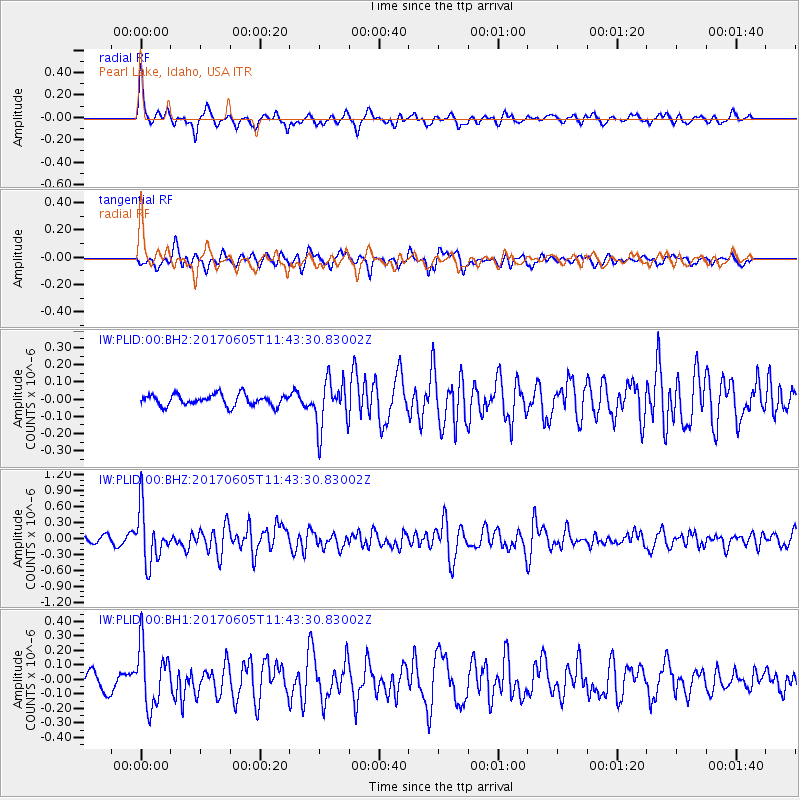
PLID Pearl Lake, Idaho, USA - Earthquake Result Viewer
*The percent match for this event was below the threshold and hence no stack was calculated.
| Earthquake location: |
Peru-Ecuador Border Region |
| Earthquake latitude/longitude: |
-4.1/-80.4 |
| Earthquake time(UTC): |
2017/06/05 (156) 11:34:11 GMT |
| Earthquake Depth: |
51 km |
| Earthquake Magnitude: |
5.6 Mww |
| Earthquake Catalog/Contributor: |
NEIC PDE/us |
|
| Network: |
IW Intermountain West |
| Station: |
PLID Pearl Lake, Idaho, USA |
| Lat/Lon: |
45.09 N/116.00 W |
| Elevation: |
2164 m |
|
| Distance: |
58.4 deg |
| Az: |
331.023 deg |
| Baz: |
136.989 deg |
| Ray Param: |
$rayparam |
*The percent match for this event was below the threshold and hence was not used in the summary stack. |
|
| Radial Match: |
75.42663 % |
| Radial Bump: |
400 |
| Transverse Match: |
65.30957 % |
| Transverse Bump: |
400 |
| SOD ConfigId: |
2140511 |
| Insert Time: |
2017-06-19 03:28:14.230 +0000 |
| GWidth: |
2.5 |
| Max Bumps: |
400 |
| Tol: |
0.001 |
|
Signal To Noise
| Channel | StoN | STA | LTA |
| IW:PLID:00:BHZ:20170605T11:43:30.83002Z | 8.883009 | 4.9670246E-7 | 5.5916015E-8 |
| IW:PLID:00:BH1:20170605T11:43:30.83002Z | 4.6250954 | 2.0774057E-7 | 4.491595E-8 |
| IW:PLID:00:BH2:20170605T11:43:30.83002Z | 4.221513 | 1.3902124E-7 | 3.2931617E-8 |
| Arrivals |
| Ps | |
| PpPs | |
| PsPs/PpSs | |


