You are here: Home > Network List > NE - New England Seismic Network Stations List
> Station EMMW Machias, ME, USA > Earthquake Result Viewer
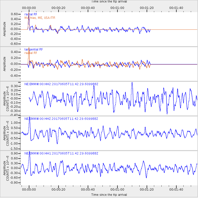
EMMW Machias, ME, USA - Earthquake Result Viewer
*The percent match for this event was below the threshold and hence no stack was calculated.
| Earthquake location: |
Peru-Ecuador Border Region |
| Earthquake latitude/longitude: |
-4.1/-80.4 |
| Earthquake time(UTC): |
2017/06/05 (156) 11:34:11 GMT |
| Earthquake Depth: |
51 km |
| Earthquake Magnitude: |
5.6 Mww |
| Earthquake Catalog/Contributor: |
NEIC PDE/us |
|
| Network: |
NE New England Seismic Network |
| Station: |
EMMW Machias, ME, USA |
| Lat/Lon: |
44.71 N/67.46 W |
| Elevation: |
35 m |
|
| Distance: |
50.0 deg |
| Az: |
12.026 deg |
| Baz: |
196.946 deg |
| Ray Param: |
$rayparam |
*The percent match for this event was below the threshold and hence was not used in the summary stack. |
|
| Radial Match: |
71.97808 % |
| Radial Bump: |
400 |
| Transverse Match: |
68.41535 % |
| Transverse Bump: |
400 |
| SOD ConfigId: |
2140511 |
| Insert Time: |
2017-06-19 03:28:29.449 +0000 |
| GWidth: |
2.5 |
| Max Bumps: |
400 |
| Tol: |
0.001 |
|
Signal To Noise
| Channel | StoN | STA | LTA |
| NE:EMMW:00:HHZ:20170605T11:42:29.609988Z | 5.0765905 | 6.489416E-7 | 1.278302E-7 |
| NE:EMMW:00:HH1:20170605T11:42:29.609988Z | 3.30008 | 4.277801E-7 | 1.2962718E-7 |
| NE:EMMW:00:HH2:20170605T11:42:29.609988Z | 1.6686672 | 1.5478005E-7 | 9.275669E-8 |
| Arrivals |
| Ps | |
| PpPs | |
| PsPs/PpSs | |


