You are here: Home > Network List > KN - Kyrgyz Seismic Telemetry Network Stations List
> Station KZA KN.KZA > Earthquake Result Viewer
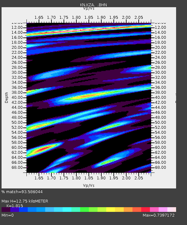
KZA KN.KZA - Earthquake Result Viewer
| Earthquake location: |
Mariana Islands |
| Earthquake latitude/longitude: |
14.5/146.8 |
| Earthquake time(UTC): |
2004/11/03 (308) 08:31:43 GMT |
| Earthquake Depth: |
10 km |
| Earthquake Magnitude: |
5.6 MB, 5.8 MS, 6.0 MW, 5.9 MW |
| Earthquake Catalog/Contributor: |
WHDF/NEIC |
|
| Network: |
KN Kyrgyz Seismic Telemetry Network |
| Station: |
KZA KN.KZA |
| Lat/Lon: |
42.08 N/75.25 E |
| Elevation: |
3520 m |
|
| Distance: |
66.8 deg |
| Az: |
309.791 deg |
| Baz: |
91.204 deg |
| Ray Param: |
0.057359323 |
| Estimated Moho Depth: |
12.75 km |
| Estimated Crust Vp/Vs: |
1.82 |
| Assumed Crust Vp: |
6.306 km/s |
| Estimated Crust Vs: |
3.474 km/s |
| Estimated Crust Poisson's Ratio: |
0.28 |
|
| Radial Match: |
93.586044 % |
| Radial Bump: |
400 |
| Transverse Match: |
72.82273 % |
| Transverse Bump: |
400 |
| SOD ConfigId: |
2459 |
| Insert Time: |
2010-03-08 20:33:36.090 +0000 |
| GWidth: |
2.5 |
| Max Bumps: |
400 |
| Tol: |
0.001 |
|

Signal To Noise
| Channel | StoN | STA | LTA |
| KN:KZA: :BHN:20041103T08:42:04.349019Z | 3.3630517 | 3.4025086E-7 | 1.0117325E-7 |
| KN:KZA: :BHE:20041103T08:42:04.349019Z | 0.8960848 | 7.5735606E-8 | 8.451835E-8 |
| KN:KZA: :BHZ:20041103T08:42:04.349019Z | 4.8536935 | 3.0423163E-7 | 6.2680435E-8 |
| Arrivals |
| Ps | 1.7 SECOND |
| PpPs | 5.5 SECOND |
| PsPs/PpSs | 7.2 SECOND |


