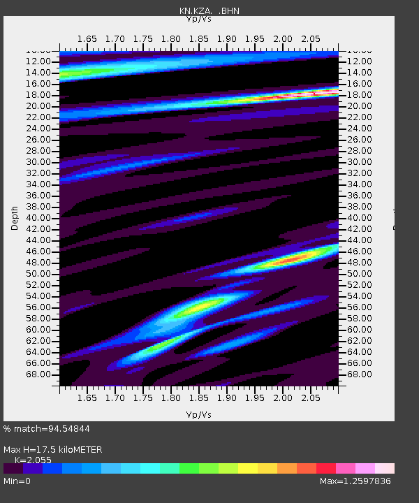
KZA KN.KZA - Earthquake Result Viewer
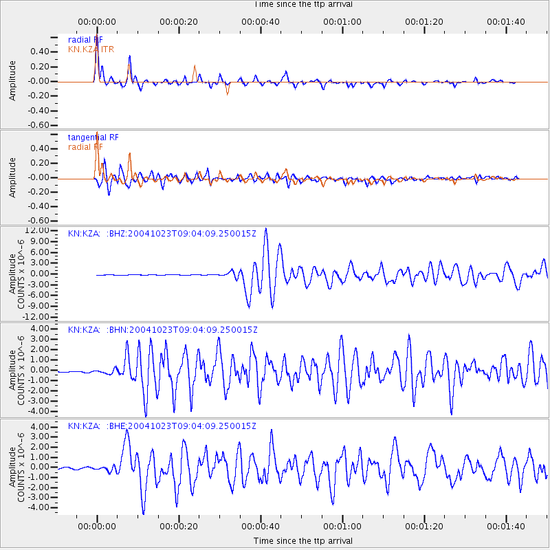
Earthquake location: Near West Coast Of Honshu, Japan
Earthquake latitude/longitude: 37.2/138.8
Earthquake time(UTC): 2004/10/23 (297) 08:56:00 GMT
Earthquake Depth: 16 km
Earthquake Magnitude: 6.4 MB, 6.3 MS, 6.6 MW, 6.4 MW
Earthquake Catalog/Contributor: WHDF/NEIC
Network: KN Kyrgyz Seismic Telemetry Network
Station: KZA KN.KZA
Lat/Lon: 42.08 N/75.25 E
Elevation: 3520 m
Distance: 48.2 deg
Az: 296.553 deg
Baz: 73.555 deg
Ray Param: 0.069522135
Estimated Moho Depth: 17.5 km
Estimated Crust Vp/Vs: 2.06
Assumed Crust Vp: 6.306 km/s
Estimated Crust Vs: 3.069 km/s
Estimated Crust Poisson's Ratio: 0.34
Radial Match: 94.54844 %
Radial Bump: 283
Transverse Match: 91.77957 %
Transverse Bump: 400
SOD ConfigId: 2459
Insert Time: 2010-03-08 20:33:39.508 +0000
GWidth: 2.5
Max Bumps: 400
Tol: 0.001

Signal To Noise

ChannelStoNSTALTA
KN:KZA: :BHN:20041023T09:04:09.250015Z2.68863652.1560918E-78.019276E-8
KN:KZA: :BHE:20041023T09:04:09.250015Z2.38552242.2388014E-79.384953E-8
KN:KZA: :BHZ:20041023T09:04:09.250015Z11.3743967.4844417E-76.580078E-8
Arrivals
Ps3.1 SECOND
PpPs8.1 SECOND
PsPs/PpSs11 SECOND