You are here: Home > Network List > KN - Kyrgyz Seismic Telemetry Network Stations List
> Station KZA KN.KZA > Earthquake Result Viewer
KZA KN.KZA - Earthquake Result Viewer
| Earthquake location: |
Hokkaido, Japan Region |
| Earthquake latitude/longitude: |
42.9/144.8 |
| Earthquake time(UTC): |
2004/04/11 (102) 18:06:12 GMT |
| Earthquake Depth: |
42 km |
| Earthquake Magnitude: |
5.7 MB, 5.7 MS, 6.1 MW, 6.1 MW |
| Earthquake Catalog/Contributor: |
WHDF/NEIC |
|
| Network: |
KN Kyrgyz Seismic Telemetry Network |
| Station: |
KZA KN.KZA |
| Lat/Lon: |
42.08 N/75.25 E |
| Elevation: |
3520 m |
|
| Distance: |
49.9 deg |
| Az: |
294.249 deg |
| Baz: |
64.117 deg |
| Ray Param: |
0.06829548 |
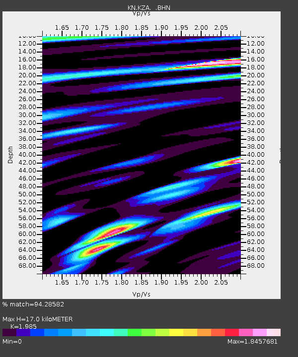
| Estimated Moho Depth: |
17.0 km |
| Estimated Crust Vp/Vs: |
1.99 |
| Assumed Crust Vp: |
6.306 km/s |
| Estimated Crust Vs: |
3.177 km/s |
| Estimated Crust Poisson's Ratio: |
0.33 |
|
| Radial Match: |
94.28582 % |
| Radial Bump: |
400 |
| Transverse Match: |
90.380714 % |
| Transverse Bump: |
400 |
| SOD ConfigId: |
2459 |
| Insert Time: |
2010-03-08 20:34:01.365 +0000 |
| GWidth: |
2.5 |
| Max Bumps: |
400 |
| Tol: |
0.001 |
|
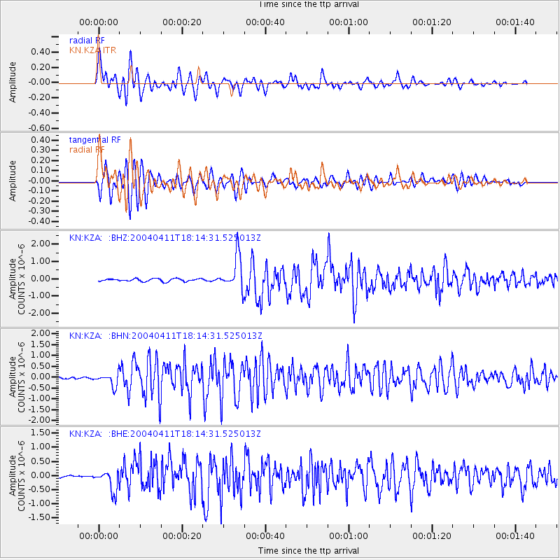
Signal To Noise
| Channel | StoN | STA | LTA |
| KN:KZA: :BHN:20040411T18:14:31.525013Z | 4.9924955 | 3.1942756E-7 | 6.3981545E-8 |
| KN:KZA: :BHE:20040411T18:14:31.525013Z | 6.5930824 | 3.7479177E-7 | 5.684621E-8 |
| KN:KZA: :BHZ:20040411T18:14:31.525013Z | 13.042047 | 1.019878E-6 | 7.819923E-8 |
| Arrivals |
| Ps | 2.8 SECOND |
| PpPs | 7.7 SECOND |
| PsPs/PpSs | 10 SECOND |


