You are here: Home > Network List > NM - Cooperative New Madrid Seismic Network Stations List
> Station HENM Henderson Mound,MO > Earthquake Result Viewer
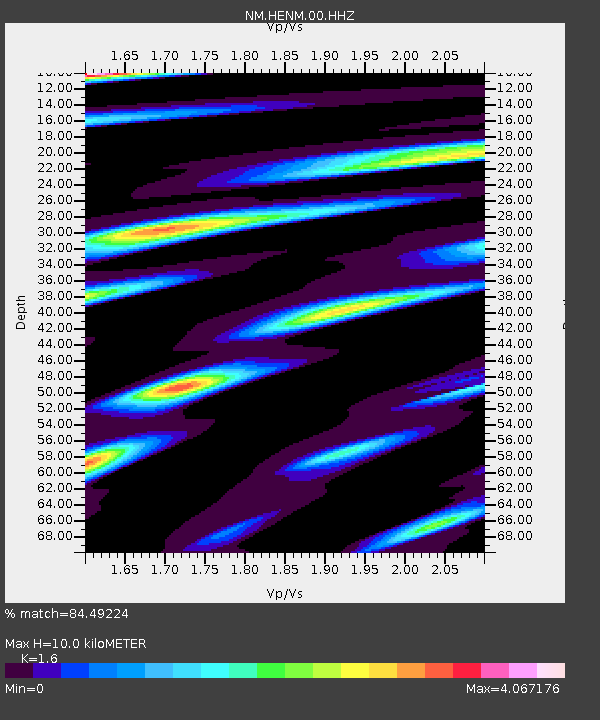
HENM Henderson Mound,MO - Earthquake Result Viewer
| Earthquake location: |
Peru-Ecuador Border Region |
| Earthquake latitude/longitude: |
-4.1/-80.4 |
| Earthquake time(UTC): |
2017/06/05 (156) 11:34:11 GMT |
| Earthquake Depth: |
51 km |
| Earthquake Magnitude: |
5.6 Mww |
| Earthquake Catalog/Contributor: |
NEIC PDE/us |
|
| Network: |
NM Cooperative New Madrid Seismic Network |
| Station: |
HENM Henderson Mound,MO |
| Lat/Lon: |
36.72 N/89.47 W |
| Elevation: |
88 m |
|
| Distance: |
41.5 deg |
| Az: |
348.954 deg |
| Baz: |
166.241 deg |
| Ray Param: |
0.073620304 |
| Estimated Moho Depth: |
10.0 km |
| Estimated Crust Vp/Vs: |
1.60 |
| Assumed Crust Vp: |
6.444 km/s |
| Estimated Crust Vs: |
4.027 km/s |
| Estimated Crust Poisson's Ratio: |
0.18 |
|
| Radial Match: |
84.49224 % |
| Radial Bump: |
366 |
| Transverse Match: |
74.359276 % |
| Transverse Bump: |
394 |
| SOD ConfigId: |
2140511 |
| Insert Time: |
2017-06-19 03:28:55.582 +0000 |
| GWidth: |
2.5 |
| Max Bumps: |
400 |
| Tol: |
0.001 |
|

Signal To Noise
| Channel | StoN | STA | LTA |
| NM:HENM:00:HHZ:20170605T11:41:22.935Z | 5.606693 | 7.501372E-7 | 1.3379316E-7 |
| NM:HENM:00:HHN:20170605T11:41:22.935Z | 5.427211 | 1.2034834E-6 | 2.217499E-7 |
| NM:HENM:00:HHE:20170605T11:41:22.935Z | 2.2823932 | 6.1295606E-7 | 2.685585E-7 |
| Arrivals |
| Ps | 1.0 SECOND |
| PpPs | 3.7 SECOND |
| PsPs/PpSs | 4.7 SECOND |


