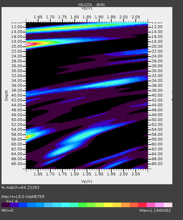
KZA KN.KZA - Earthquake Result Viewer
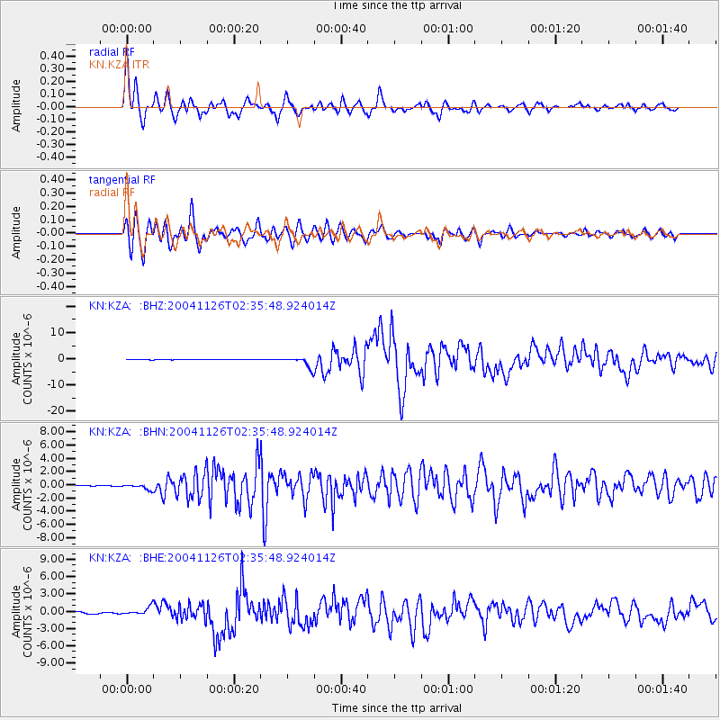
Earthquake location: Irian Jaya Region, Indonesia
Earthquake latitude/longitude: -3.6/135.4
Earthquake time(UTC): 2004/11/26 (331) 02:25:03 GMT
Earthquake Depth: 10 km
Earthquake Magnitude: 6.2 MB, 7.2 MS, 7.1 MW, 7.0 MW
Earthquake Catalog/Contributor: WHDF/NEIC
Network: KN Kyrgyz Seismic Telemetry Network
Station: KZA KN.KZA
Lat/Lon: 42.08 N/75.25 E
Elevation: 3520 m
Distance: 70.9 deg
Az: 316.878 deg
Baz: 113.598 deg
Ray Param: 0.054709066
Estimated Moho Depth: 19.0 km
Estimated Crust Vp/Vs: 1.60
Assumed Crust Vp: 6.306 km/s
Estimated Crust Vs: 3.941 km/s
Estimated Crust Poisson's Ratio: 0.18
Radial Match: 94.23293 %
Radial Bump: 400
Transverse Match: 86.1957 %
Transverse Bump: 400
SOD ConfigId: 2459
Insert Time: 2010-03-08 20:34:23.629 +0000
GWidth: 2.5
Max Bumps: 400
Tol: 0.001

Signal To Noise

ChannelStoNSTALTA
KN:KZA: :BHN:20041126T02:35:48.924014Z2.8596983.8159192E-71.3343784E-7
KN:KZA: :BHE:20041126T02:35:48.924014Z3.93692526.885113E-71.7488553E-7
KN:KZA: :BHZ:20041126T02:35:48.924014Z23.6338062.1136902E-68.9435034E-8
Arrivals
Ps1.9 SECOND
PpPs7.5 SECOND
PsPs/PpSs9.4 SECOND