You are here: Home > Network List > GS - US Geological Survey Networks Stations List
> Station ASA6 ASA6 > Earthquake Result Viewer
ASA6 ASA6 - Earthquake Result Viewer
| Earthquake location: |
Northern Mid-Atlantic Ridge |
| Earthquake latitude/longitude: |
26.0/-44.9 |
| Earthquake time(UTC): |
2020/05/30 (151) 03:21:52 GMT |
| Earthquake Depth: |
12 km |
| Earthquake Magnitude: |
5.5 Mww |
| Earthquake Catalog/Contributor: |
NEIC PDE/us |
|
| Network: |
GS US Geological Survey Networks |
| Station: |
ASA6 ASA6 |
| Lat/Lon: |
34.94 N/106.46 W |
| Elevation: |
1840 m |
|
| Distance: |
53.1 deg |
| Az: |
295.35 deg |
| Baz: |
81.793 deg |
| Ray Param: |
0.06636142 |
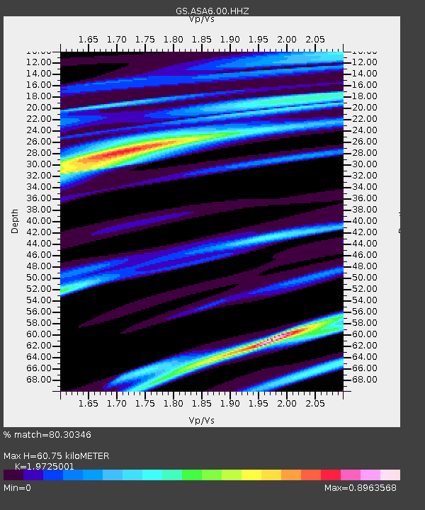
| Estimated Moho Depth: |
60.75 km |
| Estimated Crust Vp/Vs: |
1.97 |
| Assumed Crust Vp: |
6.502 km/s |
| Estimated Crust Vs: |
3.296 km/s |
| Estimated Crust Poisson's Ratio: |
0.33 |
|
| Radial Match: |
80.30346 % |
| Radial Bump: |
373 |
| Transverse Match: |
77.04143 % |
| Transverse Bump: |
396 |
| SOD ConfigId: |
21166931 |
| Insert Time: |
2020-06-13 03:30:22.374 +0000 |
| GWidth: |
2.5 |
| Max Bumps: |
400 |
| Tol: |
0.001 |
|

Signal To Noise
| Channel | StoN | STA | LTA |
| GS:ASA6:00:HHZ:20200530T03:30:37.909002Z | 1.7625189 | 1.6783916E-7 | 9.522687E-8 |
| GS:ASA6:00:HH1:20200530T03:30:37.909002Z | 2.5408208 | 1.59115E-7 | 6.262347E-8 |
| GS:ASA6:00:HH2:20200530T03:30:37.909002Z | 0.9410907 | 8.612821E-8 | 9.151957E-8 |
| Arrivals |
| Ps | 9.6 SECOND |
| PpPs | 26 SECOND |
| PsPs/PpSs | 36 SECOND |


