You are here: Home > Network List > US - United States National Seismic Network Stations List
> Station AMTX Amarillo, Texas, USA > Earthquake Result Viewer
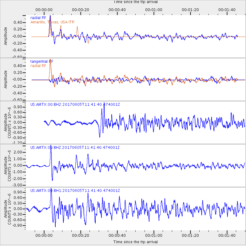
AMTX Amarillo, Texas, USA - Earthquake Result Viewer
*The percent match for this event was below the threshold and hence no stack was calculated.
| Earthquake location: |
Peru-Ecuador Border Region |
| Earthquake latitude/longitude: |
-4.1/-80.4 |
| Earthquake time(UTC): |
2017/06/05 (156) 11:34:11 GMT |
| Earthquake Depth: |
51 km |
| Earthquake Magnitude: |
5.6 Mww |
| Earthquake Catalog/Contributor: |
NEIC PDE/us |
|
| Network: |
US United States National Seismic Network |
| Station: |
AMTX Amarillo, Texas, USA |
| Lat/Lon: |
34.53 N/101.41 W |
| Elevation: |
1010 m |
|
| Distance: |
43.2 deg |
| Az: |
334.378 deg |
| Baz: |
148.503 deg |
| Ray Param: |
$rayparam |
*The percent match for this event was below the threshold and hence was not used in the summary stack. |
|
| Radial Match: |
87.11987 % |
| Radial Bump: |
400 |
| Transverse Match: |
81.6911 % |
| Transverse Bump: |
400 |
| SOD ConfigId: |
2140511 |
| Insert Time: |
2017-06-19 03:29:35.385 +0000 |
| GWidth: |
2.5 |
| Max Bumps: |
400 |
| Tol: |
0.001 |
|
Signal To Noise
| Channel | StoN | STA | LTA |
| US:AMTX:00:BHZ:20170605T11:41:40.474001Z | 12.387408 | 1.080191E-6 | 8.720073E-8 |
| US:AMTX:00:BH1:20170605T11:41:40.474001Z | 3.8958337 | 3.8049578E-7 | 9.766735E-8 |
| US:AMTX:00:BH2:20170605T11:41:40.474001Z | 3.9742813 | 3.0427552E-7 | 7.656114E-8 |
| Arrivals |
| Ps | |
| PpPs | |
| PsPs/PpSs | |


