You are here: Home > Network List > KN - Kyrgyz Seismic Telemetry Network Stations List
> Station KZA KN.KZA > Earthquake Result Viewer
KZA KN.KZA - Earthquake Result Viewer
| Earthquake location: |
Eastern Honshu, Japan |
| Earthquake latitude/longitude: |
39.8/141.5 |
| Earthquake time(UTC): |
2008/07/23 (205) 15:26:19 GMT |
| Earthquake Depth: |
108 km |
| Earthquake Magnitude: |
6.6 MB, 6.8 MW, 6.8 MW |
| Earthquake Catalog/Contributor: |
WHDF/NEIC |
|
| Network: |
KN Kyrgyz Seismic Telemetry Network |
| Station: |
KZA KN.KZA |
| Lat/Lon: |
42.08 N/75.25 E |
| Elevation: |
3520 m |
|
| Distance: |
48.9 deg |
| Az: |
295.361 deg |
| Baz: |
69.239 deg |
| Ray Param: |
0.06867195 |
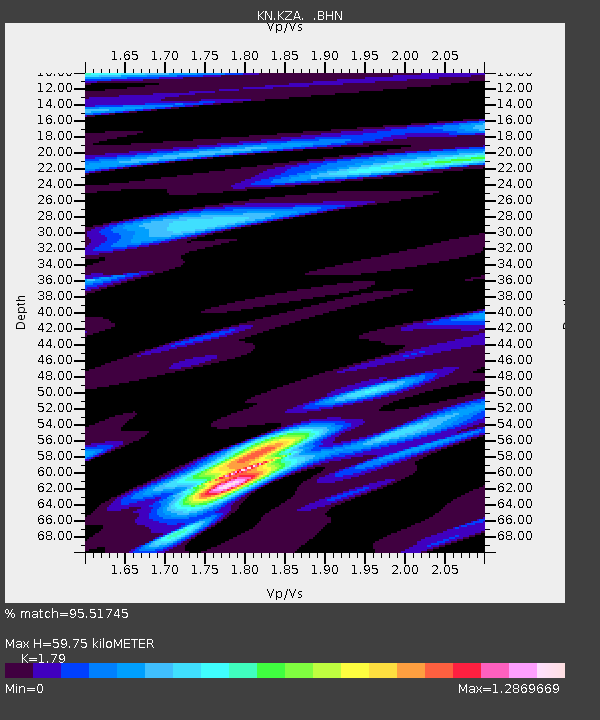
| Estimated Moho Depth: |
59.75 km |
| Estimated Crust Vp/Vs: |
1.79 |
| Assumed Crust Vp: |
6.306 km/s |
| Estimated Crust Vs: |
3.523 km/s |
| Estimated Crust Poisson's Ratio: |
0.27 |
|
| Radial Match: |
95.51745 % |
| Radial Bump: |
364 |
| Transverse Match: |
96.6931 % |
| Transverse Bump: |
383 |
| SOD ConfigId: |
2504 |
| Insert Time: |
2010-03-08 20:35:19.390 +0000 |
| GWidth: |
2.5 |
| Max Bumps: |
400 |
| Tol: |
0.001 |
|
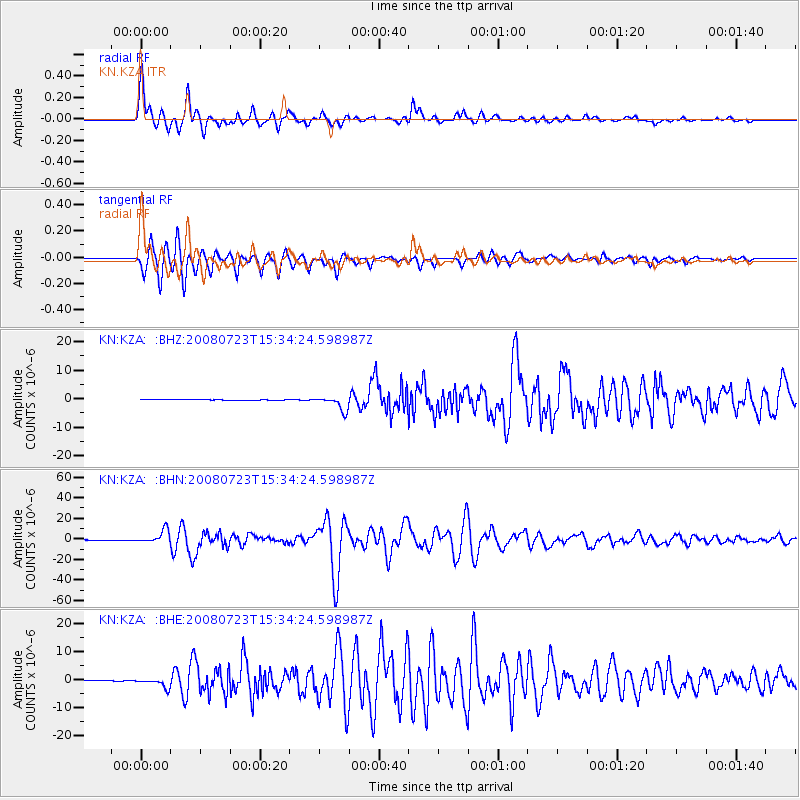
Signal To Noise
| Channel | StoN | STA | LTA |
| KN:KZA: :BHN:20080723T15:34:24.598987Z | 100.891914 | 6.316381E-6 | 6.260543E-8 |
| KN:KZA: :BHE:20080723T15:34:24.598987Z | 11.164279 | 1.5535618E-6 | 1.391547E-7 |
| KN:KZA: :BHZ:20080723T15:34:24.598987Z | 20.109858 | 2.511137E-6 | 1.2487095E-7 |
| Arrivals |
| Ps | 7.9 SECOND |
| PpPs | 25 SECOND |
| PsPs/PpSs | 33 SECOND |


