You are here: Home > Network List > KN - Kyrgyz Seismic Telemetry Network Stations List
> Station KZA KN.KZA > Earthquake Result Viewer
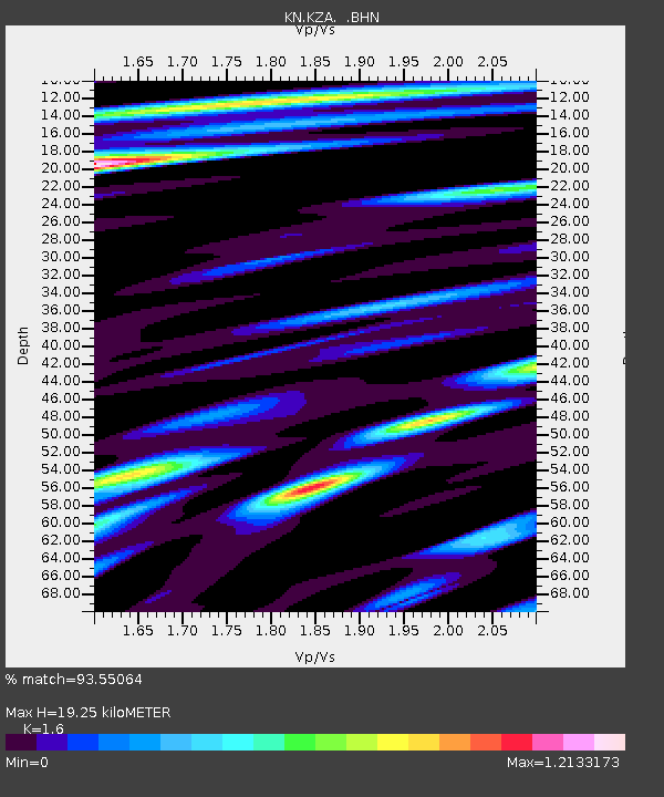
KZA KN.KZA - Earthquake Result Viewer
| Earthquake location: |
Eastern New Guinea Reg., P.N.G. |
| Earthquake latitude/longitude: |
-6.1/147.3 |
| Earthquake time(UTC): |
2008/08/30 (243) 06:54:07 GMT |
| Earthquake Depth: |
75 km |
| Earthquake Magnitude: |
6.1 MB, 6.4 MW, 6.3 MW |
| Earthquake Catalog/Contributor: |
WHDF/NEIC |
|
| Network: |
KN Kyrgyz Seismic Telemetry Network |
| Station: |
KZA KN.KZA |
| Lat/Lon: |
42.08 N/75.25 E |
| Elevation: |
3520 m |
|
| Distance: |
80.9 deg |
| Az: |
314.19 deg |
| Baz: |
106.728 deg |
| Ray Param: |
0.047786675 |
| Estimated Moho Depth: |
19.25 km |
| Estimated Crust Vp/Vs: |
1.60 |
| Assumed Crust Vp: |
6.306 km/s |
| Estimated Crust Vs: |
3.941 km/s |
| Estimated Crust Poisson's Ratio: |
0.18 |
|
| Radial Match: |
93.55064 % |
| Radial Bump: |
400 |
| Transverse Match: |
89.63627 % |
| Transverse Bump: |
400 |
| SOD ConfigId: |
2504 |
| Insert Time: |
2010-03-08 20:35:26.609 +0000 |
| GWidth: |
2.5 |
| Max Bumps: |
400 |
| Tol: |
0.001 |
|

Signal To Noise
| Channel | StoN | STA | LTA |
| KN:KZA: :BHN:20080830T07:05:42.724014Z | 16.928492 | 1.0660658E-6 | 6.297465E-8 |
| KN:KZA: :BHE:20080830T07:05:42.724014Z | 2.9065754 | 1.3163431E-7 | 4.5288456E-8 |
| KN:KZA: :BHZ:20080830T07:05:42.724014Z | 6.188845 | 2.5075497E-7 | 4.0517246E-8 |
| Arrivals |
| Ps | 1.9 SECOND |
| PpPs | 7.7 SECOND |
| PsPs/PpSs | 9.6 SECOND |


