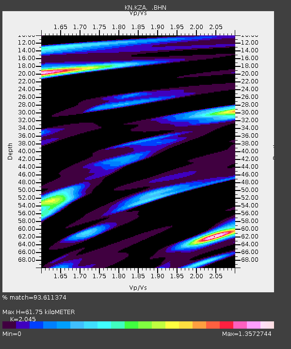
KZA KN.KZA - Earthquake Result Viewer
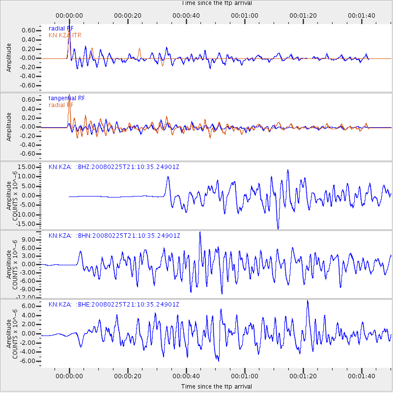
Earthquake location: Southern Sumatra, Indonesia
Earthquake latitude/longitude: -2.2/99.8
Earthquake time(UTC): 2008/02/25 (056) 21:02:18 GMT
Earthquake Depth: 25 km
Earthquake Magnitude: 6.2 MB, 6.6 MS, 6.6 MW, 6.5 MW
Earthquake Catalog/Contributor: WHDF/NEIC
Network: KN Kyrgyz Seismic Telemetry Network
Station: KZA KN.KZA
Lat/Lon: 42.08 N/75.25 E
Elevation: 3520 m
Distance: 49.4 deg
Az: 335.955 deg
Baz: 146.846 deg
Ray Param: 0.068678364
Estimated Moho Depth: 61.75 km
Estimated Crust Vp/Vs: 2.05
Assumed Crust Vp: 6.306 km/s
Estimated Crust Vs: 3.084 km/s
Estimated Crust Poisson's Ratio: 0.34
Radial Match: 93.611374 %
Radial Bump: 400
Transverse Match: 90.861206 %
Transverse Bump: 400
SOD ConfigId: 2564
Insert Time: 2010-03-08 20:35:43.971 +0000
GWidth: 2.5
Max Bumps: 400
Tol: 0.001

Signal To Noise

ChannelStoNSTALTA
KN:KZA: :BHN:20080225T21:10:35.24901Z4.66852862.0422992E-64.37461E-7
KN:KZA: :BHE:20080225T21:10:35.24901Z4.05622861.1106162E-62.738051E-7
KN:KZA: :BHZ:20080225T21:10:35.24901Z25.080444.050937E-61.6151779E-7
Arrivals
Ps11 SECOND
PpPs28 SECOND
PsPs/PpSs39 SECOND