You are here: Home > Network List > AV - Alaska Volcano Observatory Stations List
> Station PLBL Mt. Peulik Volcano, Alaska > Earthquake Result Viewer
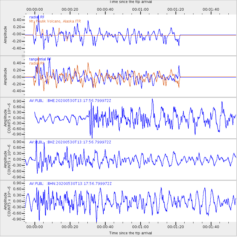
PLBL Mt. Peulik Volcano, Alaska - Earthquake Result Viewer
*The percent match for this event was below the threshold and hence no stack was calculated.
| Earthquake location: |
Talaud Islands, Indonesia |
| Earthquake latitude/longitude: |
4.0/126.6 |
| Earthquake time(UTC): |
2020/05/30 (151) 13:06:24 GMT |
| Earthquake Depth: |
31 km |
| Earthquake Magnitude: |
5.5 Mww |
| Earthquake Catalog/Contributor: |
NEIC PDE/us |
|
| Network: |
AV Alaska Volcano Observatory |
| Station: |
PLBL Mt. Peulik Volcano, Alaska |
| Lat/Lon: |
57.70 N/156.82 W |
| Elevation: |
461 m |
|
| Distance: |
79.4 deg |
| Az: |
32.088 deg |
| Baz: |
260.74 deg |
| Ray Param: |
$rayparam |
*The percent match for this event was below the threshold and hence was not used in the summary stack. |
|
| Radial Match: |
74.60343 % |
| Radial Bump: |
400 |
| Transverse Match: |
39.36204 % |
| Transverse Bump: |
386 |
| SOD ConfigId: |
21166931 |
| Insert Time: |
2020-06-13 13:10:33.005 +0000 |
| GWidth: |
2.5 |
| Max Bumps: |
400 |
| Tol: |
0.001 |
|
Signal To Noise
| Channel | StoN | STA | LTA |
| AV:PLBL: :BHZ:20200530T13:17:56.799972Z | 3.3379438 | 3.6649004E-7 | 1.0979515E-7 |
| AV:PLBL: :BHN:20200530T13:17:56.799972Z | 1.9968282 | 3.34636E-7 | 1.6758378E-7 |
| AV:PLBL: :BHE:20200530T13:17:56.799972Z | 3.1311758 | 4.3876855E-7 | 1.40129E-7 |
| Arrivals |
| Ps | |
| PpPs | |
| PsPs/PpSs | |


