You are here: Home > Network List > US - United States National Seismic Network Stations List
> Station GLMI Grayling, Michigan, USA > Earthquake Result Viewer
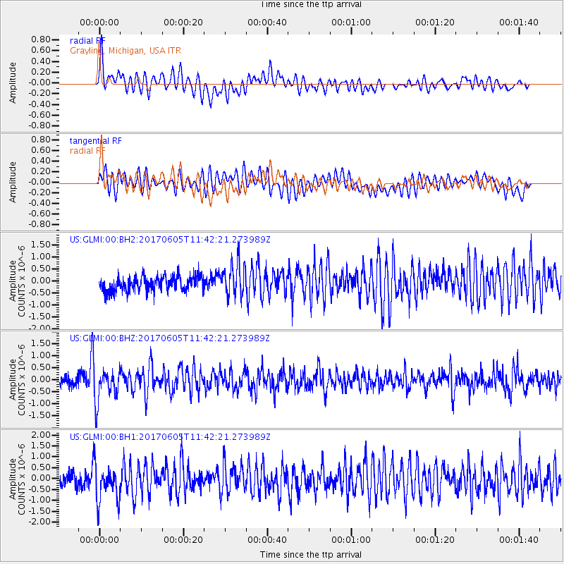
GLMI Grayling, Michigan, USA - Earthquake Result Viewer
*The percent match for this event was below the threshold and hence no stack was calculated.
| Earthquake location: |
Peru-Ecuador Border Region |
| Earthquake latitude/longitude: |
-4.1/-80.4 |
| Earthquake time(UTC): |
2017/06/05 (156) 11:34:11 GMT |
| Earthquake Depth: |
51 km |
| Earthquake Magnitude: |
5.6 Mww |
| Earthquake Catalog/Contributor: |
NEIC PDE/us |
|
| Network: |
US United States National Seismic Network |
| Station: |
GLMI Grayling, Michigan, USA |
| Lat/Lon: |
44.82 N/84.62 W |
| Elevation: |
387 m |
|
| Distance: |
48.9 deg |
| Az: |
355.999 deg |
| Baz: |
174.388 deg |
| Ray Param: |
$rayparam |
*The percent match for this event was below the threshold and hence was not used in the summary stack. |
|
| Radial Match: |
71.99689 % |
| Radial Bump: |
400 |
| Transverse Match: |
68.305786 % |
| Transverse Bump: |
400 |
| SOD ConfigId: |
2140511 |
| Insert Time: |
2017-06-19 03:30:00.042 +0000 |
| GWidth: |
2.5 |
| Max Bumps: |
400 |
| Tol: |
0.001 |
|
Signal To Noise
| Channel | StoN | STA | LTA |
| US:GLMI:00:BHZ:20170605T11:42:21.273989Z | 3.5828118 | 6.795687E-7 | 1.8967468E-7 |
| US:GLMI:00:BH1:20170605T11:42:21.273989Z | 2.6911964 | 8.0277795E-7 | 2.9829778E-7 |
| US:GLMI:00:BH2:20170605T11:42:21.273989Z | 2.1933808 | 6.8583176E-7 | 3.126825E-7 |
| Arrivals |
| Ps | |
| PpPs | |
| PsPs/PpSs | |


