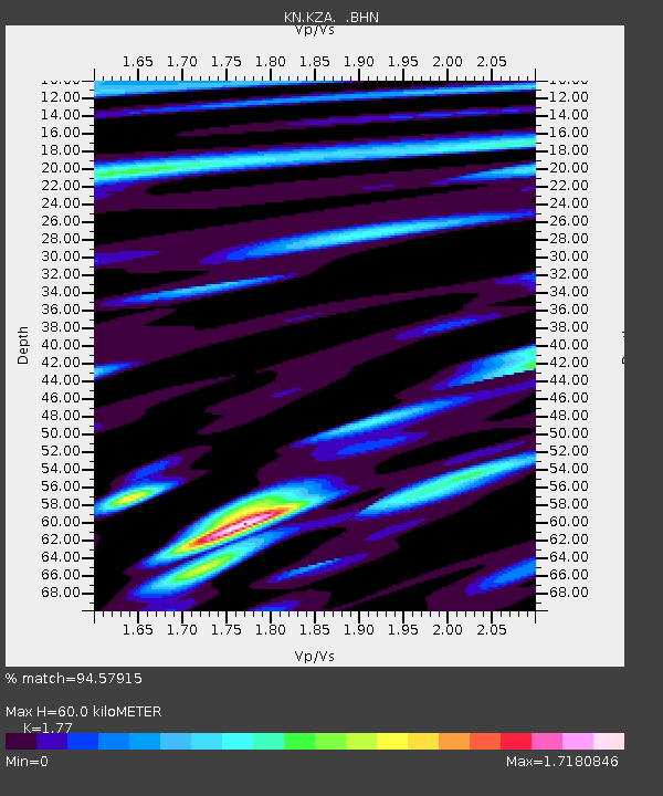
KZA KN.KZA - Earthquake Result Viewer
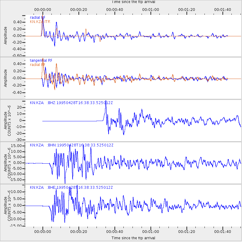
Earthquake location: Kuril Islands
Earthquake latitude/longitude: 44.1/148.1
Earthquake time(UTC): 1995/04/28 (118) 16:30:00 GMT
Earthquake Depth: 29 km
Earthquake Magnitude: 6.6 MB, 6.9 MS, 7.0 UNKNOWN, 6.8 MW
Earthquake Catalog/Contributor: WHDF/NEIC
Network: KN Kyrgyz Seismic Telemetry Network
Station: KZA KN.KZA
Lat/Lon: 42.08 N/75.25 E
Elevation: 3520 m
Distance: 51.6 deg
Az: 294.815 deg
Baz: 61.523 deg
Ray Param: 0.06726614
Estimated Moho Depth: 60.0 km
Estimated Crust Vp/Vs: 1.77
Assumed Crust Vp: 6.306 km/s
Estimated Crust Vs: 3.563 km/s
Estimated Crust Poisson's Ratio: 0.27
Radial Match: 94.57915 %
Radial Bump: 400
Transverse Match: 87.717545 %
Transverse Bump: 400
SOD ConfigId: 6273
Insert Time: 2010-03-08 20:36:22.510 +0000
GWidth: 2.5
Max Bumps: 400
Tol: 0.001

Signal To Noise

ChannelStoNSTALTA
KN:KZA: :BHN:19950428T16:38:33.525012Z22.9548031.1240479E-64.8967873E-8
KN:KZA: :BHE:19950428T16:38:33.525012Z32.7775341.5187759E-64.633588E-8
KN:KZA: :BHZ:19950428T16:38:33.525012Z104.93375.3037506E-65.0543825E-8
Arrivals
Ps7.7 SECOND
PpPs25 SECOND
PsPs/PpSs33 SECOND