You are here: Home > Network List > TA - USArray Transportable Network (new EarthScope stations) Stations List
> Station B22K Teshekpuk Lake, AK, USA > Earthquake Result Viewer
B22K Teshekpuk Lake, AK, USA - Earthquake Result Viewer
| Earthquake location: |
Talaud Islands, Indonesia |
| Earthquake latitude/longitude: |
4.0/126.6 |
| Earthquake time(UTC): |
2020/05/30 (151) 13:06:24 GMT |
| Earthquake Depth: |
31 km |
| Earthquake Magnitude: |
5.5 Mww |
| Earthquake Catalog/Contributor: |
NEIC PDE/us |
|
| Network: |
TA USArray Transportable Network (new EarthScope stations) |
| Station: |
B22K Teshekpuk Lake, AK, USA |
| Lat/Lon: |
70.34 N/153.42 W |
| Elevation: |
50 m |
|
| Distance: |
82.9 deg |
| Az: |
19.626 deg |
| Baz: |
261.887 deg |
| Ray Param: |
0.04656081 |
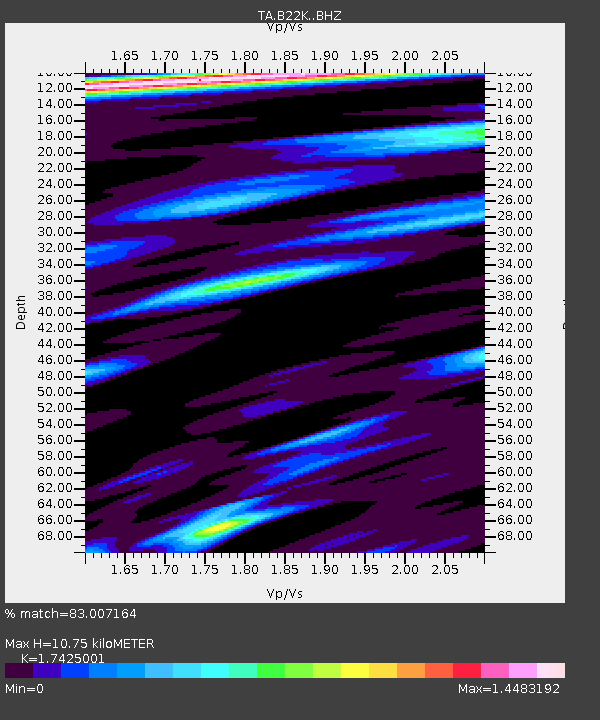
| Estimated Moho Depth: |
10.75 km |
| Estimated Crust Vp/Vs: |
1.74 |
| Assumed Crust Vp: |
5.738 km/s |
| Estimated Crust Vs: |
3.293 km/s |
| Estimated Crust Poisson's Ratio: |
0.25 |
|
| Radial Match: |
83.007164 % |
| Radial Bump: |
400 |
| Transverse Match: |
71.55899 % |
| Transverse Bump: |
400 |
| SOD ConfigId: |
21166931 |
| Insert Time: |
2020-06-13 13:15:09.416 +0000 |
| GWidth: |
2.5 |
| Max Bumps: |
400 |
| Tol: |
0.001 |
|

Signal To Noise
| Channel | StoN | STA | LTA |
| TA:B22K: :BHZ:20200530T13:18:14.874984Z | 8.427425 | 8.764964E-7 | 1.0400524E-7 |
| TA:B22K: :BHN:20200530T13:18:14.874984Z | 0.8381412 | 1.0116776E-7 | 1.2070491E-7 |
| TA:B22K: :BHE:20200530T13:18:14.874984Z | 2.0902677 | 2.0420369E-7 | 9.76926E-8 |
| Arrivals |
| Ps | 1.4 SECOND |
| PpPs | 5.0 SECOND |
| PsPs/PpSs | 6.5 SECOND |


