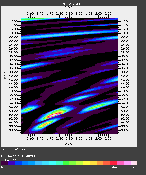
KZA KN.KZA - Earthquake Result Viewer
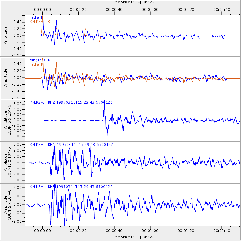
Earthquake location: Kuril Islands
Earthquake latitude/longitude: 44.0/148.1
Earthquake time(UTC): 1995/03/11 (070) 15:21:10 GMT
Earthquake Depth: 33 km
Earthquake Magnitude: 6.0 MB, 5.7 MS, 6.1 UNKNOWN, 5.9 MW
Earthquake Catalog/Contributor: WHDF/NEIC
Network: KN Kyrgyz Seismic Telemetry Network
Station: KZA KN.KZA
Lat/Lon: 42.08 N/75.25 E
Elevation: 3520 m
Distance: 51.7 deg
Az: 294.886 deg
Baz: 61.551 deg
Ray Param: 0.06720697
Estimated Moho Depth: 60.0 km
Estimated Crust Vp/Vs: 1.77
Assumed Crust Vp: 6.306 km/s
Estimated Crust Vs: 3.563 km/s
Estimated Crust Poisson's Ratio: 0.27
Radial Match: 93.77326 %
Radial Bump: 400
Transverse Match: 88.368996 %
Transverse Bump: 400
SOD ConfigId: 6273
Insert Time: 2010-03-08 20:36:42.601 +0000
GWidth: 2.5
Max Bumps: 400
Tol: 0.001

Signal To Noise

ChannelStoNSTALTA
KN:KZA: :BHN:19950311T15:29:43.650012Z6.4134256.3095865E-79.838092E-8
KN:KZA: :BHE:19950311T15:29:43.650012Z6.9949445.6355606E-78.0566195E-8
KN:KZA: :BHZ:19950311T15:29:43.650012Z29.4597151.9509193E-66.62233E-8
Arrivals
Ps7.7 SECOND
PpPs25 SECOND
PsPs/PpSs33 SECOND