You are here: Home > Network List > TA - USArray Transportable Network (new EarthScope stations) Stations List
> Station G23K Bananza Creek, AK, USA > Earthquake Result Viewer
G23K Bananza Creek, AK, USA - Earthquake Result Viewer
| Earthquake location: |
Talaud Islands, Indonesia |
| Earthquake latitude/longitude: |
4.0/126.6 |
| Earthquake time(UTC): |
2020/05/30 (151) 13:06:24 GMT |
| Earthquake Depth: |
31 km |
| Earthquake Magnitude: |
5.5 Mww |
| Earthquake Catalog/Contributor: |
NEIC PDE/us |
|
| Network: |
TA USArray Transportable Network (new EarthScope stations) |
| Station: |
G23K Bananza Creek, AK, USA |
| Lat/Lon: |
66.71 N/150.02 W |
| Elevation: |
746 m |
|
| Distance: |
83.7 deg |
| Az: |
23.413 deg |
| Baz: |
265.489 deg |
| Ray Param: |
0.045964245 |
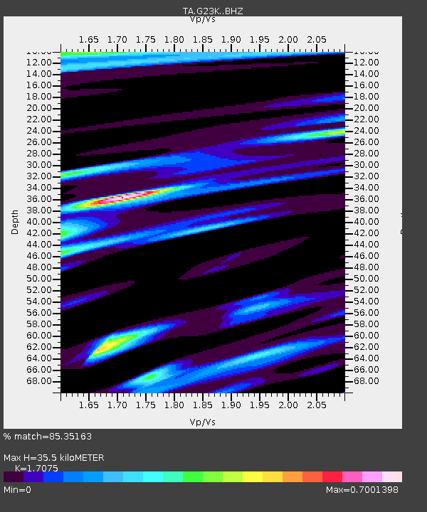
| Estimated Moho Depth: |
35.5 km |
| Estimated Crust Vp/Vs: |
1.71 |
| Assumed Crust Vp: |
6.577 km/s |
| Estimated Crust Vs: |
3.852 km/s |
| Estimated Crust Poisson's Ratio: |
0.24 |
|
| Radial Match: |
85.35163 % |
| Radial Bump: |
400 |
| Transverse Match: |
74.359795 % |
| Transverse Bump: |
400 |
| SOD ConfigId: |
21166931 |
| Insert Time: |
2020-06-13 13:16:18.893 +0000 |
| GWidth: |
2.5 |
| Max Bumps: |
400 |
| Tol: |
0.001 |
|
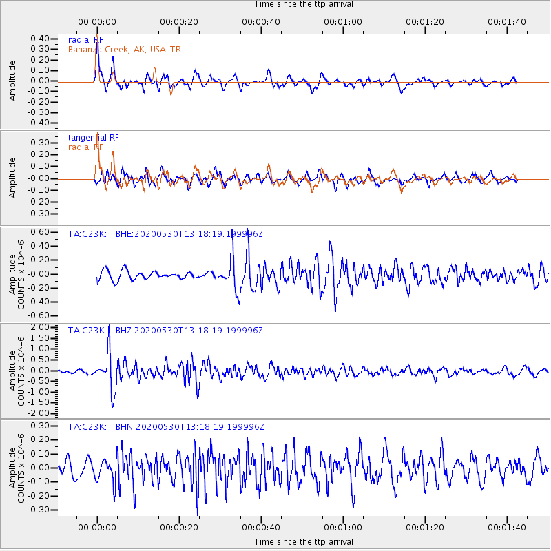
Signal To Noise
| Channel | StoN | STA | LTA |
| TA:G23K: :BHZ:20200530T13:18:19.199996Z | 16.438557 | 8.46371E-7 | 5.1486943E-8 |
| TA:G23K: :BHN:20200530T13:18:19.199996Z | 1.0137707 | 7.877317E-8 | 7.770314E-8 |
| TA:G23K: :BHE:20200530T13:18:19.199996Z | 3.8862305 | 2.408213E-7 | 6.196784E-8 |
| Arrivals |
| Ps | 3.9 SECOND |
| PpPs | 14 SECOND |
| PsPs/PpSs | 18 SECOND |


