You are here: Home > Network List > KN - Kyrgyz Seismic Telemetry Network Stations List
> Station KZA KN.KZA > Earthquake Result Viewer
KZA KN.KZA - Earthquake Result Viewer
| Earthquake location: |
Mariana Islands |
| Earthquake latitude/longitude: |
18.9/145.2 |
| Earthquake time(UTC): |
1995/08/23 (235) 07:06:02 GMT |
| Earthquake Depth: |
596 km |
| Earthquake Magnitude: |
6.3 MB, 6.3 UNKNOWN, 7.0 MW |
| Earthquake Catalog/Contributor: |
WHDF/NEIC |
|
| Network: |
KN Kyrgyz Seismic Telemetry Network |
| Station: |
KZA KN.KZA |
| Lat/Lon: |
42.08 N/75.25 E |
| Elevation: |
3520 m |
|
| Distance: |
62.8 deg |
| Az: |
308.196 deg |
| Baz: |
88.566 deg |
| Ray Param: |
0.057667304 |
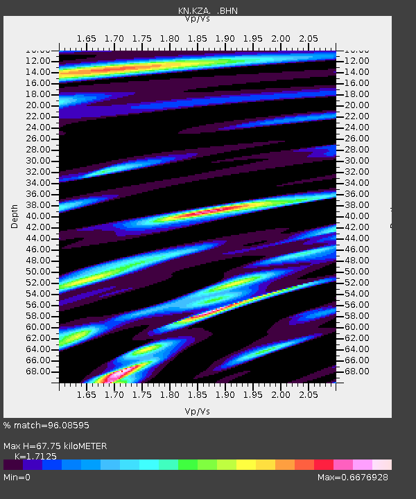
| Estimated Moho Depth: |
67.75 km |
| Estimated Crust Vp/Vs: |
1.71 |
| Assumed Crust Vp: |
6.306 km/s |
| Estimated Crust Vs: |
3.682 km/s |
| Estimated Crust Poisson's Ratio: |
0.24 |
|
| Radial Match: |
96.08595 % |
| Radial Bump: |
357 |
| Transverse Match: |
92.64768 % |
| Transverse Bump: |
400 |
| SOD ConfigId: |
6273 |
| Insert Time: |
2010-03-08 20:37:03.503 +0000 |
| GWidth: |
2.5 |
| Max Bumps: |
400 |
| Tol: |
0.001 |
|
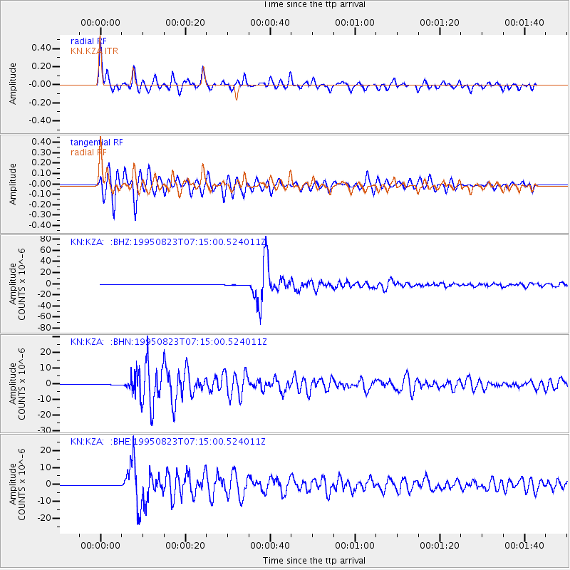
Signal To Noise
| Channel | StoN | STA | LTA |
| KN:KZA: :BHN:19950823T07:15:00.524011Z | 0.7078936 | 1.3727612E-7 | 1.9392198E-7 |
| KN:KZA: :BHE:19950823T07:15:00.524011Z | 1.5973775 | 3.4659524E-7 | 2.1697767E-7 |
| KN:KZA: :BHZ:19950823T07:15:00.524011Z | 4.0560246 | 2.893696E-7 | 7.1343166E-8 |
| Arrivals |
| Ps | 8.0 SECOND |
| PpPs | 28 SECOND |
| PsPs/PpSs | 36 SECOND |


