You are here: Home > Network List > TA - USArray Transportable Network (new EarthScope stations) Stations List
> Station I17K Unalakleet, AK, USA > Earthquake Result Viewer
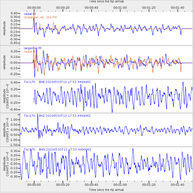
I17K Unalakleet, AK, USA - Earthquake Result Viewer
*The percent match for this event was below the threshold and hence no stack was calculated.
| Earthquake location: |
Talaud Islands, Indonesia |
| Earthquake latitude/longitude: |
4.0/126.6 |
| Earthquake time(UTC): |
2020/05/30 (151) 13:06:24 GMT |
| Earthquake Depth: |
31 km |
| Earthquake Magnitude: |
5.5 Mww |
| Earthquake Catalog/Contributor: |
NEIC PDE/us |
|
| Network: |
TA USArray Transportable Network (new EarthScope stations) |
| Station: |
I17K Unalakleet, AK, USA |
| Lat/Lon: |
63.89 N/160.70 W |
| Elevation: |
105 m |
|
| Distance: |
78.8 deg |
| Az: |
25.509 deg |
| Baz: |
256.117 deg |
| Ray Param: |
$rayparam |
*The percent match for this event was below the threshold and hence was not used in the summary stack. |
|
| Radial Match: |
59.34669 % |
| Radial Bump: |
400 |
| Transverse Match: |
63.69801 % |
| Transverse Bump: |
400 |
| SOD ConfigId: |
21166931 |
| Insert Time: |
2020-06-13 13:16:37.361 +0000 |
| GWidth: |
2.5 |
| Max Bumps: |
400 |
| Tol: |
0.001 |
|
Signal To Noise
| Channel | StoN | STA | LTA |
| TA:I17K: :BHZ:20200530T13:17:53.449996Z | 3.0868382 | 4.737279E-7 | 1.5346704E-7 |
| TA:I17K: :BHN:20200530T13:17:53.449996Z | 0.95946 | 1.4443982E-7 | 1.5054282E-7 |
| TA:I17K: :BHE:20200530T13:17:53.449996Z | 1.4042766 | 1.9067527E-7 | 1.3578185E-7 |
| Arrivals |
| Ps | |
| PpPs | |
| PsPs/PpSs | |


