You are here: Home > Network List > TA - USArray Transportable Network (new EarthScope stations) Stations List
> Station M16K Timber Creek, AK, USA > Earthquake Result Viewer
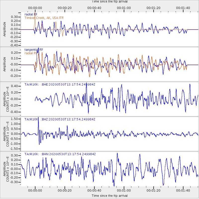
M16K Timber Creek, AK, USA - Earthquake Result Viewer
*The percent match for this event was below the threshold and hence no stack was calculated.
| Earthquake location: |
Talaud Islands, Indonesia |
| Earthquake latitude/longitude: |
4.0/126.6 |
| Earthquake time(UTC): |
2020/05/30 (151) 13:06:24 GMT |
| Earthquake Depth: |
31 km |
| Earthquake Magnitude: |
5.5 Mww |
| Earthquake Catalog/Contributor: |
NEIC PDE/us |
|
| Network: |
TA USArray Transportable Network (new EarthScope stations) |
| Station: |
M16K Timber Creek, AK, USA |
| Lat/Lon: |
61.02 N/158.96 W |
| Elevation: |
394 m |
|
| Distance: |
79.0 deg |
| Az: |
28.548 deg |
| Baz: |
258.239 deg |
| Ray Param: |
$rayparam |
*The percent match for this event was below the threshold and hence was not used in the summary stack. |
|
| Radial Match: |
48.159267 % |
| Radial Bump: |
400 |
| Transverse Match: |
73.742905 % |
| Transverse Bump: |
400 |
| SOD ConfigId: |
21166931 |
| Insert Time: |
2020-06-13 13:17:02.376 +0000 |
| GWidth: |
2.5 |
| Max Bumps: |
400 |
| Tol: |
0.001 |
|
Signal To Noise
| Channel | StoN | STA | LTA |
| TA:M16K: :BHZ:20200530T13:17:54.249984Z | 5.2499804 | 5.0932954E-7 | 9.701551E-8 |
| TA:M16K: :BHN:20200530T13:17:54.249984Z | 0.8391964 | 8.645794E-8 | 1.0302468E-7 |
| TA:M16K: :BHE:20200530T13:17:54.249984Z | 1.747047 | 1.6544985E-7 | 9.470257E-8 |
| Arrivals |
| Ps | |
| PpPs | |
| PsPs/PpSs | |


