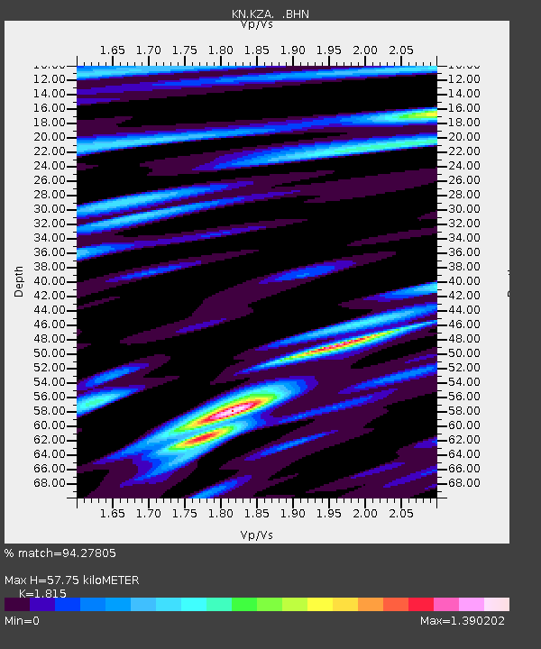
KZA KN.KZA - Earthquake Result Viewer

Earthquake location: Eastern Honshu, Japan
Earthquake latitude/longitude: 38.9/140.5
Earthquake time(UTC): 1996/08/10 (223) 18:12:17 GMT
Earthquake Depth: 10 km
Earthquake Magnitude: 6.0 MB, 5.7 MS, 5.9 UNKNOWN, 5.9 MW
Earthquake Catalog/Contributor: WHDF/NEIC
Network: KN Kyrgyz Seismic Telemetry Network
Station: KZA KN.KZA
Lat/Lon: 42.08 N/75.25 E
Elevation: 3520 m
Distance: 48.7 deg
Az: 295.749 deg
Baz: 70.724 deg
Ray Param: 0.069214076
Estimated Moho Depth: 57.75 km
Estimated Crust Vp/Vs: 1.82
Assumed Crust Vp: 6.306 km/s
Estimated Crust Vs: 3.474 km/s
Estimated Crust Poisson's Ratio: 0.28
Radial Match: 94.27805 %
Radial Bump: 400
Transverse Match: 88.9657 %
Transverse Bump: 400
SOD ConfigId: 6273
Insert Time: 2010-03-08 20:37:29.922 +0000
GWidth: 2.5
Max Bumps: 400
Tol: 0.001

Signal To Noise

ChannelStoNSTALTA
KN:KZA: :BHN:19960810T18:20:30.448987Z1.10969837.691801E-86.931435E-8
KN:KZA: :BHE:19960810T18:20:30.448987Z7.29905651.887135E-72.5854508E-8
KN:KZA: :BHZ:19960810T18:20:30.448987Z14.6117015.620402E-73.846508E-8
Arrivals
Ps7.9 SECOND
PpPs24 SECOND
PsPs/PpSs32 SECOND