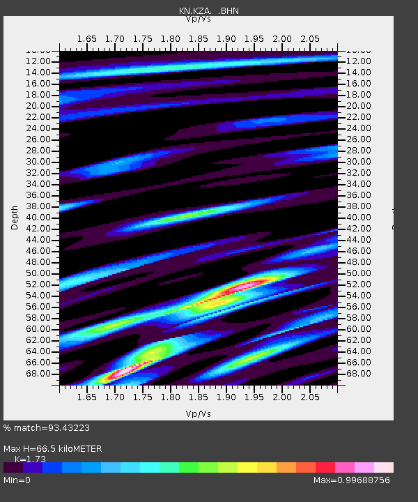
KZA KN.KZA - Earthquake Result Viewer
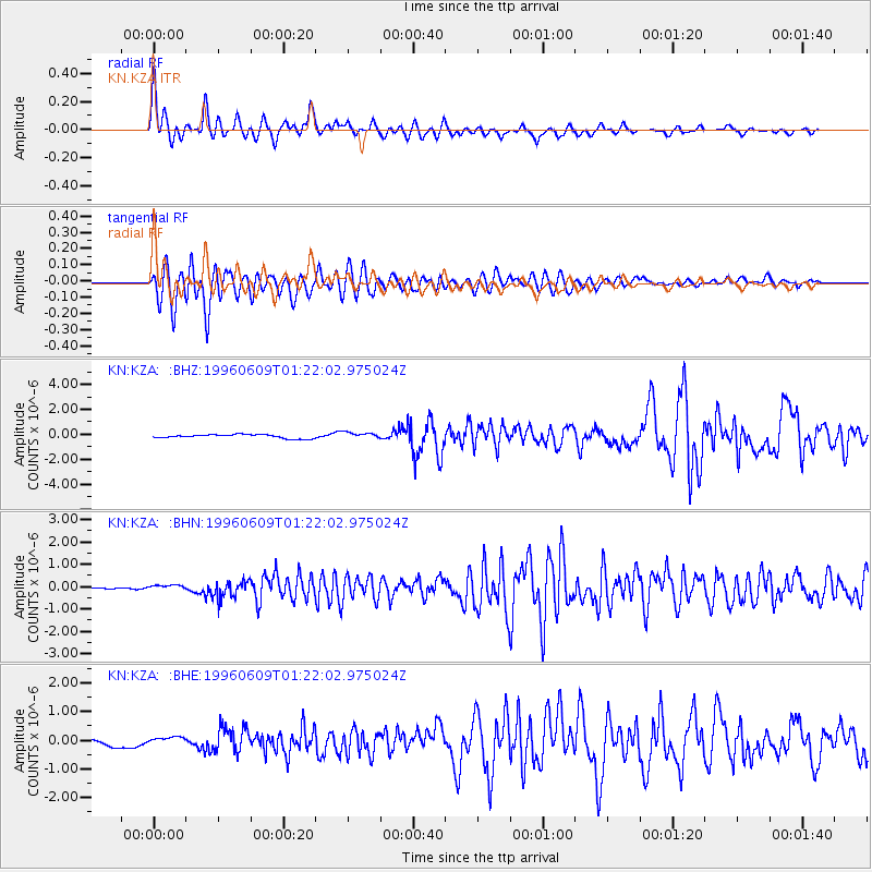
Earthquake location: Mariana Islands
Earthquake latitude/longitude: 17.4/145.5
Earthquake time(UTC): 1996/06/09 (161) 01:12:16 GMT
Earthquake Depth: 149 km
Earthquake Magnitude: 6.0 MB, 5.9 MS, 6.5 UNKNOWN, 6.5 MW
Earthquake Catalog/Contributor: WHDF/NEIC
Network: KN Kyrgyz Seismic Telemetry Network
Station: KZA KN.KZA
Lat/Lon: 42.08 N/75.25 E
Elevation: 3520 m
Distance: 63.9 deg
Az: 308.751 deg
Baz: 89.617 deg
Ray Param: 0.058828235
Estimated Moho Depth: 66.5 km
Estimated Crust Vp/Vs: 1.73
Assumed Crust Vp: 6.306 km/s
Estimated Crust Vs: 3.645 km/s
Estimated Crust Poisson's Ratio: 0.25
Radial Match: 93.43223 %
Radial Bump: 388
Transverse Match: 88.38178 %
Transverse Bump: 400
SOD ConfigId: 6273
Insert Time: 2010-03-08 20:37:40.637 +0000
GWidth: 2.5
Max Bumps: 400
Tol: 0.001

Signal To Noise

ChannelStoNSTALTA
KN:KZA: :BHN:19960609T01:22:02.975024Z1.7296581.6424353E-79.495722E-8
KN:KZA: :BHE:19960609T01:22:02.975024Z1.18189311.2465425E-71.0546999E-7
KN:KZA: :BHZ:19960609T01:22:02.975024Z1.59411332.424566E-71.5209494E-7
Arrivals
Ps8.0 SECOND
PpPs28 SECOND
PsPs/PpSs36 SECOND