You are here: Home > Network List > CI - Caltech Regional Seismic Network Stations List
> Station MPM Manuel Prospect Mine, California, USA > Earthquake Result Viewer
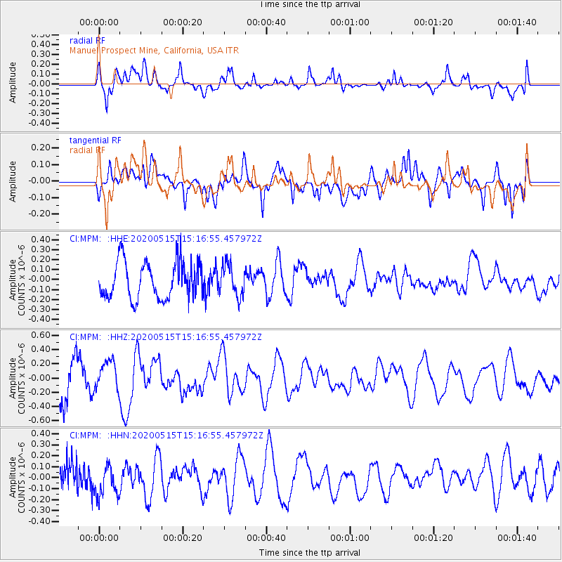
MPM Manuel Prospect Mine, California, USA - Earthquake Result Viewer
*The percent match for this event was below the threshold and hence no stack was calculated.
| Earthquake location: |
Samoa Islands Region |
| Earthquake latitude/longitude: |
-15.8/-172.9 |
| Earthquake time(UTC): |
2020/05/15 (136) 15:05:55 GMT |
| Earthquake Depth: |
19 km |
| Earthquake Magnitude: |
5.6 Mww |
| Earthquake Catalog/Contributor: |
NEIC PDE/us |
|
| Network: |
CI Caltech Regional Seismic Network |
| Station: |
MPM Manuel Prospect Mine, California, USA |
| Lat/Lon: |
36.06 N/117.49 W |
| Elevation: |
185 m |
|
| Distance: |
73.5 deg |
| Az: |
44.086 deg |
| Baz: |
235.756 deg |
| Ray Param: |
$rayparam |
*The percent match for this event was below the threshold and hence was not used in the summary stack. |
|
| Radial Match: |
66.76438 % |
| Radial Bump: |
400 |
| Transverse Match: |
63.204674 % |
| Transverse Bump: |
400 |
| SOD ConfigId: |
21166931 |
| Insert Time: |
2020-06-13 14:22:39.320 +0000 |
| GWidth: |
2.5 |
| Max Bumps: |
400 |
| Tol: |
0.001 |
|
Signal To Noise
| Channel | StoN | STA | LTA |
| CI:MPM: :HHZ:20200515T15:16:55.457972Z | 1.0567323 | 2.0835235E-7 | 1.9716664E-7 |
| CI:MPM: :HHN:20200515T15:16:55.457972Z | 1.1223283 | 1.5782902E-7 | 1.4062643E-7 |
| CI:MPM: :HHE:20200515T15:16:55.457972Z | 0.88426304 | 1.6138821E-7 | 1.8251154E-7 |
| Arrivals |
| Ps | |
| PpPs | |
| PsPs/PpSs | |


