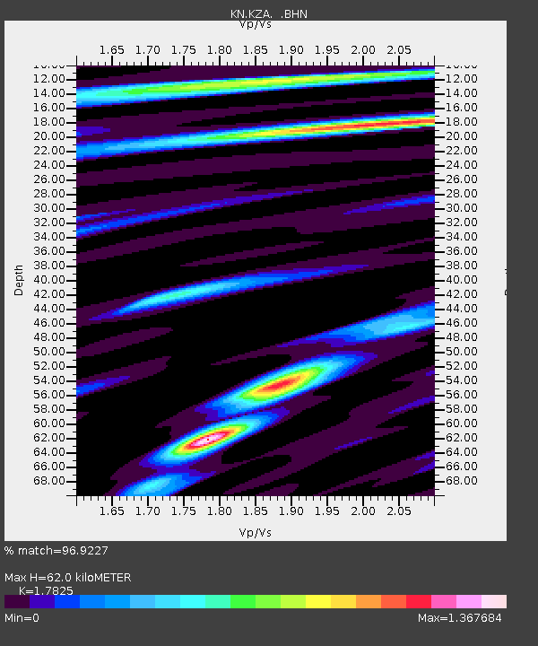
KZA KN.KZA - Earthquake Result Viewer
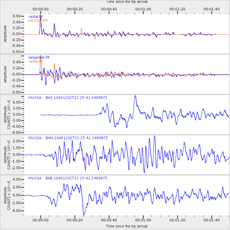
Earthquake location: Kyushu, Japan
Earthquake latitude/longitude: 31.8/131.3
Earthquake time(UTC): 1996/12/02 (337) 22:17:59 GMT
Earthquake Depth: 49 km
Earthquake Magnitude: 6.0 MB, 6.6 MS, 6.8 UNKNOWN, 6.3 ME
Earthquake Catalog/Contributor: WHDF/NEIC
Network: KN Kyrgyz Seismic Telemetry Network
Station: KZA KN.KZA
Lat/Lon: 42.08 N/75.25 E
Elevation: 3520 m
Distance: 45.3 deg
Az: 299.586 deg
Baz: 84.111 deg
Ray Param: 0.071264595
Estimated Moho Depth: 62.0 km
Estimated Crust Vp/Vs: 1.78
Assumed Crust Vp: 6.306 km/s
Estimated Crust Vs: 3.538 km/s
Estimated Crust Poisson's Ratio: 0.27
Radial Match: 96.9227 %
Radial Bump: 348
Transverse Match: 87.863945 %
Transverse Bump: 400
SOD ConfigId: 6273
Insert Time: 2010-03-08 20:38:11.075 +0000
GWidth: 2.5
Max Bumps: 400
Tol: 0.001

Signal To Noise

ChannelStoNSTALTA
KN:KZA: :BHN:19961202T22:25:41.348987Z0.94476191.1138341E-71.17895745E-7
KN:KZA: :BHE:19961202T22:25:41.348987Z3.18267512.0210852E-76.350272E-8
KN:KZA: :BHZ:19961202T22:25:41.348987Z4.5234083.5400458E-77.826059E-8
Arrivals
Ps8.2 SECOND
PpPs26 SECOND
PsPs/PpSs34 SECOND