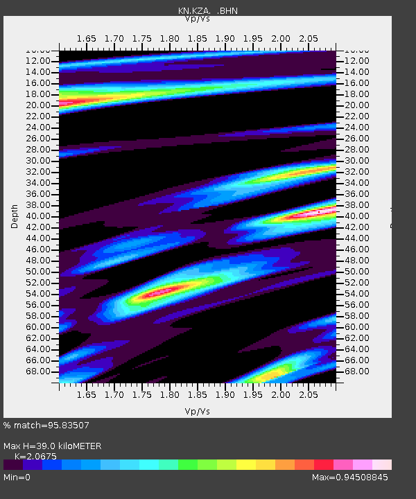
KZA KN.KZA - Earthquake Result Viewer

Earthquake location: Minahassa Peninsula, Sulawesi
Earthquake latitude/longitude: 0.7/120.0
Earthquake time(UTC): 1996/01/01 (001) 08:05:11 GMT
Earthquake Depth: 33 km
Earthquake Magnitude: 6.2 MB, 7.7 MS, 7.8 UNKNOWN, 7.8 MW
Earthquake Catalog/Contributor: WHDF/NEIC
Network: KN Kyrgyz Seismic Telemetry Network
Station: KZA KN.KZA
Lat/Lon: 42.08 N/75.25 E
Elevation: 3520 m
Distance: 57.5 deg
Az: 321.596 deg
Baz: 123.451 deg
Ray Param: 0.063391015
Estimated Moho Depth: 39.0 km
Estimated Crust Vp/Vs: 2.07
Assumed Crust Vp: 6.306 km/s
Estimated Crust Vs: 3.05 km/s
Estimated Crust Poisson's Ratio: 0.35
Radial Match: 95.83507 %
Radial Bump: 400
Transverse Match: 86.066895 %
Transverse Bump: 400
SOD ConfigId: 6273
Insert Time: 2010-03-08 20:38:20.020 +0000
GWidth: 2.5
Max Bumps: 400
Tol: 0.001

Signal To Noise

ChannelStoNSTALTA
KN:KZA: :BHN:19960101T08:14:27.175024Z2.54860576.9077623E-72.7104085E-7
KN:KZA: :BHE:19960101T08:14:27.175024Z2.96501768.5610066E-72.8873376E-7
KN:KZA: :BHZ:19960101T08:14:27.175024Z5.31108952.2315405E-64.201662E-7
Arrivals
Ps6.9 SECOND
PpPs18 SECOND
PsPs/PpSs25 SECOND